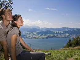
hiking paradise Grünberg in Gmunden - Traunmüllersteig
Starting place: 4810 Gmunden
Destination: 4810 Gmunden
Already at the uphill ride with the "grünberg" cable car, you can enjoy a magnificent view over Gmunden, the lake Traunsee and the impressive mountain scenery.
Starting place: 4810 Gmunden
Destination: 4810 Gmunden
duration: 1h 58m
length: 2,6 km
Altitude difference (uphill): 495m
Altitude difference (downhill): 15m
Lowest point: 460m
Highest point: 955m
difficulty: medium
condition: medium
panoramic view: Some Views
Paths covering:
Climbing mount, Hiking trail
Starting point: Gmunden - Weyer
Destination: Grünberg
Accessibility / arrival
departure Regau-B145 in the direction of Bad Ischl-through the center of Gmunden-across the bridge "Traunbrücke"-at the traffic light turn right in the direction to the cable car "Grünbergseilbahn"
Most economical season
- Summer
Please get in touch for more information.
Toscanapark 1
4810 Gmunden
Phone +43 7612 74451
E-Mail info@traunsee-almtal.at
Web www.gruenberg.info
http://www.gruenberg.info


