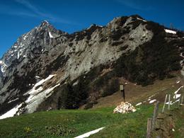
Bosruck – border mountain with four summit crosses
Path number: 610, 611
Starting place: 4582 Spital am Pyhrn
Destination: 4582 Spital am Pyhrn
The province border between Upper Austria and Styria runs through the Bosruck mountain at Spital am Pyhrn, with its mighty oak summit cross of the mountain rescue team Spital am Pyhrn.
Its abrupt ridges – the west and northeast ridge demand absolute sure-footedness and there is partly danger for vertigo sufferers!There are 2 paths leading from the 945 m high Pyhrn pass towards the Fuchsalm. Trail nr. 611 begins at the pass height on the B 138(main road), opposite the former Pyhrner Inn. Trail nr. 610 begins after the pass height, diagonally opposite the winter service garage of the B 138, as forest road.
From the Fuchsalm trail nr. 610 leads through the forest and over steep alpine meadows in serpentines to the Lahnerkogel mountain (summit cross 1854 m), walking time about 2 ½ hrs. From here the ridge hike begins over the Kitzstein mountain (summit cross 1925 m) to the summit of the Bosruck mountain.
The ascent route over the northeast ridge turns off trail nr. 613 at the Arling saddle (1425m) and leads to the so called access tower, secured as alpine climb on to the Frauenmauer mountain (summit cross) over the partly exposed ridge to the summit of the Bosruck. Ascent time about 2 ½ hours.
Accessibility / arrival
Parking on the summit of the Pyhrnpass.
ATTENTION! Parking at the pier in front of the Pyhrn 38 is not permitted. This is private property and parking is traded here with an ownership suit.
Most economical season
- Summer
- Autumn
Please get in touch for more information.
Stiftsplatz 1
4582 Spital am Pyhrn
Phone +43 7563 249
Fax machine +43 7563 249 - 20
E-Mail spital@pyhrn-priel.net
Web www.urlaubsregion-pyhrn-priel.at/
https://www.urlaubsregion-pyhrn-priel.at/


