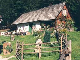
Oberweng - Pramfelderreith Alpine Hut
Starting place: 4582 Spital am Pyhrn
Destination: 4582 Spital am Pyhrn
Stiftsplatz 7
4582 Spital am Pyhrn
4582 Spital am Pyhrn

The starting point is the Flindermühle below the Singerskogel snack bar in Oberweng near Spital am Pyhrn. Here you walk to the Pugl farm in the direction of Winklertal. Directly after this farm, the trail leads left towards Pramfelderreith.
A forest road leads leisurely uphill past the Hotz ski lift, the "Unter- und Oberfahrenberg" houses that are no longer farmed, through the high forest to Pramfelderreith.
A forest road leads leisurely uphill past the Hotz ski lift, the "Unter- und Oberfahrenberg" houses that are no longer farmed, through the high forest to Pramfelderreith.
Starting place: 4582 Spital am Pyhrn
Destination: 4582 Spital am Pyhrn
duration: 1h 13m
length: 3,2 km
Altitude difference (uphill): 250m
Altitude difference (downhill): 11m
Lowest point: 846m
Highest point: 1.084m
difficulty: easy
condition: easy
panoramic view: Some Views
Paths covering:
Gravel, Other
Starting point: Flinder Mill in Oberweng below the Jausenstube Singerskogel
Destination: Pramfelderreith Alpine Hut in Spital am Pyhrn
further information:
- Board possible
Accessibility / arrival
Flinder Mill in Oberweng
Most economical season
- Spring
- Summer
- Autumn
Please get in touch for more information.
Stiftsplatz 7
4582 Spital am Pyhrn
Phone +43 7563 249 - 99
Fax machine +43 7563 249 - 20
E-Mail spital@pyhrn-priel.net
Web www.urlaubsregion-pyhrn-priel.at
https://www.urlaubsregion-pyhrn-priel.at


