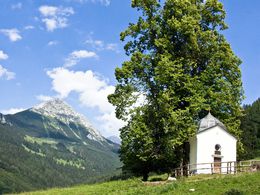
Small monuments along the way "Testaments of the Smith’s Trade”
Path number: 601, 613
Starting place: 4582 Spital am Pyhrn
Destination: 4582 Spital am Pyhrn
Stiftsplatz 1
4582 Spital am Pyhrn
4582 Spital am Pyhrn

Walking time: 2 ½ hours
Level of difficulty: blaue/red
Stations: choir gate in the former monastery church – lattice at the „Beinhaus“ (north side of church) – grave crosses at the cemetery of the St. Leonhard Church – experience and display smithey Lindermayr (blacksmith workshop) – Weinmeister chapel – Grünauer chapel – Ochsenwald chapel.
Path number: 601, 613
Starting place: 4582 Spital am Pyhrn
Destination: 4582 Spital am Pyhrn
duration: 2h 57m
length: 8,1 km
Altitude difference (uphill): 567m
Altitude difference (downhill): 78m
Lowest point: 640m
Highest point: 1.129m
difficulty: medium
condition: medium
panoramic view: Some Views
Paths covering:
Asphalt, Gravel, Hiking trail
Starting point: Collegiate Church Spital am Phyrn - Cathedral on Phyrn
Destination: Ochsenwald chapel
further information:
- Board possible
Accessibility / arrival
Parking at the Monastery place in Spital am Pyhrn
Most economical season
- Spring
- Summer
- Autumn
Please get in touch for more information.
Stiftsplatz 1
4582 Spital am Pyhrn
Phone +43 7563 249
Fax machine +43 7563 249 - 20
E-Mail spital@pyhrn-priel.net
Web www.urlaubsregion-pyhrn-priel.at
https://www.urlaubsregion-pyhrn-priel.at


