Karleck Circular Hike
Path number: 601, 613, 630
Starting place: 4582 Spital am Pyhrn
Destination: 4582 Spital am Pyhrn
Stiftsplatz 1
4582 Spital am Pyhrn
4582 Spital am Pyhrn

Experience a varied circular hike with fantastic views: From the Bosruckhütte, the route leads over the Brandtner-Höhe and the Arlingsattel to the Bacheralm, on to the Rohrauerhaus and back to the starting point.
The starting point is the Bosruckhütte parking lot in Spital am Pyhrn.
From here, hike past the Bosruckhütte in the direction of the Rohrauerhaus. At the first junction, take the forest road to the Arlingalmen and continue to the Arlingsattel. Then take trail no. 613 downhill towards Ardning.
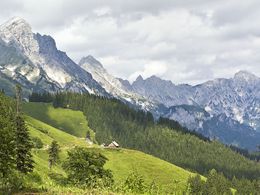
On the Styrian side, you hike across a steep alpine meadow to the forest road, continue left to the Bacheralm (not managed) and slightly uphill to the Pyhrgasgatterl. Here you have a wonderful view of the Haller Mauern. You will reach the Rohrauerhaus in just a few minutes on trail no. 601.
After a refreshment stop, return to the starting point.
Path number: 601, 613, 630
Starting place: 4582 Spital am Pyhrn
Destination: 4582 Spital am Pyhrn
duration: 3h 45m
length: 8,8 km
Altitude difference (uphill): 591m
Altitude difference (downhill): 584m
Lowest point: 1.059m
Highest point: 1.423m
difficulty: medium
condition: medium
panoramic view: Great panorama
Paths covering:
Hiking trail
Starting point: Bosruckhütte
further information:
- Flatly
- Possible accommodation
- Board possible
Accessibility / arrival
Parking at the Bosruckhütte
Most economical season
- Spring
- Summer
- Autumn
Please get in touch for more information.
Stiftsplatz 1
4582 Spital am Pyhrn
Phone +43 7563 249
Fax machine +43 7563 249 - 20
E-Mail spital@pyhrn-priel.net
Web www.urlaubsregion-pyhrn-priel.at
https://www.urlaubsregion-pyhrn-priel.at


