

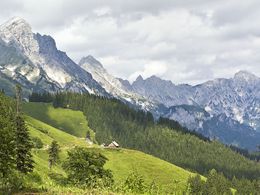
Karleck Circular Hike


- Flatly
- Possible accommodation
Interactive elevation profile
Create PDF
Tour-Details
Path number: 601, 613, 630
Starting place: 4582 Spital am Pyhrn
Destination: 4582 Spital am Pyhrn
duration: 3h 45m
length: 8,8 km
Altitude difference (uphill): 591m
Altitude difference (downhill): 584m
Lowest point: 1.059m
Highest point: 1.423m
difficulty: medium
condition: medium
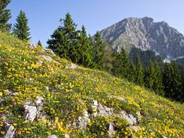
panoramic view: Great panorama
Paths covering:
Hiking trail
powered by TOURDATA
Trail-Nr: 601, 613
Walking time: about 3 hrs.
Level of difficulty: red
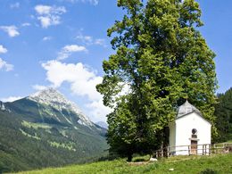
Refreshment stops: Rohrauerhaus, Bosruckhütte (mountain inn & hut) Starting point is the alpine hut Bosruckhütte in Spital am Pyhrn – trail nr. 601 direction Rohrauerhaus – turn off forest road to your right, see sign at the so- Brandtner-Hight– slightly ascending to the Arlingalm pasture and the Arling saddle – onto trail nr. 613. Descent on the Styrian side via steep alpine meadows to a forest road – continue to your left, slightly ascending along the forest road to the Bacheralm (unmanaged pasture & hut) and further up via an alpine meadow to the „Pyhrgas Gatterl“ with impressive view to the Hallermauern mountains and along trail nr. 601 back to the Rohrauerhaus in a view minutes – back to your starting point on trail nr. 601.
Walking time: about 3 hrs.
Level of difficulty: red
Refreshment stops: Rohrauerhaus, Bosruckhütte (mountain inn & hut) Starting point is the alpine hut Bosruckhütte in Spital am Pyhrn – trail nr. 601 direction Rohrauerhaus – turn off forest road to your right, see sign at the so- Brandtner-Hight– slightly ascending to the Arlingalm pasture and the Arling saddle – onto trail nr. 613. Descent on the Styrian side via steep alpine meadows to a forest road – continue to your left, slightly ascending along the forest road to the Bacheralm (unmanaged pasture & hut) and further up via an alpine meadow to the „Pyhrgas Gatterl“ with impressive view to the Hallermauern mountains and along trail nr. 601 back to the Rohrauerhaus in a view minutes – back to your starting point on trail nr. 601.
Starting point: Bosruckhütte
further information:
- Flatly
- Possible accommodation
- Board possible
")
")
Accessibility / arrival
Parking at the Bosruckhütte
Most economical season
- Spring
- Summer
- Autumn
Please get in touch for more information.

Stiftsplatz 1
4582 Spital am Pyhrn
Phone +43 7563 249
Fax machine +43 7563 249 - 20
E-Mail spital@pyhrn-priel.net
Web www.urlaubsregion-pyhrn-priel.at
https://www.urlaubsregion-pyhrn-priel.at
Interactive elevation profile
Create PDF
Tour-Details
Path number: 601, 613, 630
Starting place: 4582 Spital am Pyhrn
Destination: 4582 Spital am Pyhrn
duration: 3h 45m
length: 8,8 km
Altitude difference (uphill): 591m
Altitude difference (downhill): 584m
Lowest point: 1.059m
Highest point: 1.423m
difficulty: medium
condition: medium
panoramic view: Great panorama
Paths covering:
Hiking trail
powered by TOURDATA