Old Pilgrimage Trail
Path number: 613
Starting place: 4582 Spital am Pyhrn
Destination: 8911 Ardning
The old pilgrimage trail leads you from the gorge exit (Dr. Vogelgesang gorge) in Spital am Pyhrn over the Arlingsattel into Styria to Ardning.
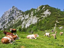
After a short stop at the beautiful chapel the steep ascent leads through a larch forest to the Arlingalm (not managed pasture) and to the Arlingsaddle 1.466 m with stunning long distance views into the valleys Teichtal and Ennstal. From here pilgrimage trail nr. 613 leads in steep serpentines to the Ardningalm, on to Ardning and to the pilgrimage church Frauenberg in the Styrian part of the Ennstal valley, walking time from the Arlingsaddle about 3,5 hours.
From the Arlingalm pasture a flat forest road leads slightly descending to trail tr. 601 and to the huts Rohrauerhaus or back to the Bosruckhütte, walking time about 30 min or 45 min.
Path number: 613
Starting place: 4582 Spital am Pyhrn
Destination: 8911 Ardning
duration: 4h 10m
length: 11,0 km
Altitude difference (uphill): 554m
Altitude difference (downhill): 819m
Lowest point: 637m
Highest point: 1.407m
difficulty: medium
condition: medium
panoramic view: Great panorama
Paths covering:
Gravel, Hiking trail
Starting point: Dr. Vogelgesang-Gorge
Destination: Station Ardning
further information:
- Board possible
Accessibility / arrival
In Spital am Pyhrn, follow signs for the car park for Dr. Vogelgesang-Klamm! 47.657311, 14.353449
Most economical season
- Summer
- Autumn
Please get in touch for more information.
Stiftsplatz 1
4582 Spital am Pyhrn
Phone +43 7563 249
E-Mail spital@pyhrn-priel.net
Web www.urlaubsregion-pyhrn-priel.at/
https://www.urlaubsregion-pyhrn-priel.at/


