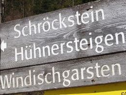
Schröckstein - Kleine Hühnersteige – Trainstation Pießling
Path number: 27
Starting place: 4575 Roßleithen
Destination: 4575 Roßleithen
Hike from Schröckstein to the community of Rettenbach, then via the Kleiner Hühnersteig to the former Piessling railway station.
From the Schröckstein in Rading at Roßleithen (trail nr. 462) via the bridge (Rettenbach) left on a forest road rising slightly, then leading left onto a forest path up to a saddle, where you turn left onto trail nr. 20 to Windischgarsten, a meadow path leading through the forest, then a tar road to the railway crossing, then left (trail nr. 28a from the Stummer farm) to the trainstation. (Here connection AV trail nr 291 (alpine club trail) to the alpine hut Zellerhütte, nr. 293 to alpine hut Dümlerhütte via Roßleithen.)Trail-Nr: 27
Path number: 27
Starting place: 4575 Roßleithen
Destination: 4575 Roßleithen
duration: 0h 36m
length: 2,0 km
Altitude difference (uphill): 47m
Altitude difference (downhill): 82m
Lowest point: 558m
Highest point: 611m
difficulty: very easy
condition: very easy
panoramic view: Some Views
Paths covering:
Asphalt, Hiking trail
Starting point: In rading until Rettenbach, turn left up to Schröckstein.
Destination: The former railway station in Pießling Roßleithen.
Accessibility / arrival
by car:
From the north on the A9 direction Graz - exit Roßleithen,
from the south on the A9 direction Linz departure Roßleithen.
by train:
Pyhrnbahn (Linz - Graz) stop Windischgarsten
Most economical season
- Spring
- Summer
- Autumn
Please get in touch for more information.
Bahnhofstraße 2
4580 Windischgarsten
Phone +43 7562 5266
Fax machine +43 7562 5266 - 10
E-Mail info@pyhrn-priel.net
Web www.urlaubsregion-pyhrn-priel.at/
https://www.urlaubsregion-pyhrn-priel.at/


