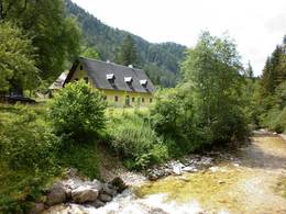
© Photo: Oberösterreich Tourismus GmbH./Robert Maybach: Enjoy the view in Upper Austria
Enjoy the view in Upper Austria
Search
Search
Close

The Forest Ranger House in the Rettenbach Valley

 Interactive elevation profile

Download GPS data
Create PDF

Tour-Details

Path number: 25,20,463
Starting place: 4580 Windischgarsten
Destination: 4575 Roßleithen

duration: 1h 47m
length: 5,9 km
Altitude difference (uphill): 182m
Altitude difference (downhill): 128m

Lowest point: 578m
Highest point: 665m
difficulty: very easy
condition: very easy
panoramic view: Individual Views

Paths covering:
Asphalt

powered by TOURDATA

Take Trail Nr. 20 or 24 to get there – turn right at the entrance to the Rettenbachtal valley and walk along to the forest rangers house ( Försterhaus). Take the same trail back to the end of the valley – either via the Veichltal valley or via Rading to the Kalvarienberg mountain.

Trail-Number: 25
Walking Time: approx. ¾ hour
Accessibility / arrival

by car:
Motorway A1 - exit Voralpenkreuz on the A9 (Pyhrnautobahn) direction Graz - exit Roßleithen / Windischgarsten

by train:
Hauptbahnhof Linz - Windischgarsten
Graz - Selzthal - Windischgarsten

Travelling by public transport
Route planner for independent travellers
Most economical season
  • Spring
  • Summer
  • Autumn

Please get in touch for more information.


The Forest Ranger House in the Rettenbach Valley
Pyhrn-Priel Tourismus GmbH
Bahnhofstraße 2
4580 Windischgarsten

Phone +43 7562 5266
Fax machine +43 7562 5266 - 10
E-Mail info@pyhrn-priel.net
Web www.urlaubsregion-pyhrn-priel.at
http://www.urlaubsregion-pyhrn-priel.at

We speak the following languages

German

 Interactive elevation profile

Download GPS data
Create PDF

Tour-Details

Path number: 25,20,463
Starting place: 4580 Windischgarsten
Destination: 4575 Roßleithen

duration: 1h 47m
length: 5,9 km
Altitude difference (uphill): 182m
Altitude difference (downhill): 128m

Lowest point: 578m
Highest point: 665m
difficulty: very easy
condition: very easy
panoramic view: Individual Views

Paths covering:
Asphalt

powered by TOURDATA