© Foto Oberösterreich Tourismus GmbH/Robert Maybach: Schneeschuwandern im Mühlviertel in der Nähe von Bad Zell.
Search
Search
Close

Klaus - Frauenstein

 Interactive elevation profile

Download GPS data
Create PDF

Tour-Details

Starting place: 4564 Klaus an der Pyhrnbahn
Destination: 4591 Molln

duration: 1h 1m
length: 3,9 km
Altitude difference (uphill): 39m
Altitude difference (downhill): 25m

Lowest point: 417m
Highest point: 482m
difficulty: easy
condition: easy
panoramic view: Individual Views

Paths covering:
Asphalt, Hiking trail

powered by TOURDATA

Along trail nr. 1 from Klaus via the reservoir dam or the Ecklbrunner bridge (below the municipal office) to the east bank of the river Steyr, then left in northerly direction along the river on easy and shady paths to Frauenstein. From Frauenstein continue to Steyrdurchbruch.

Return to Klaus by bus.
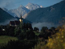
Pilgrimage church with 16th century madonna

Trail-Nr: 1
Starting point: Klaus center
Destination: Frauenstein

further information:
  • Board possible

Accessibility / arrival

by car:
From Vienna: West motorway direction Salzburg - A1 junction Voralpenkreuz - A9 exit Klaus

From Munich: A8 Salzburg - West motorway A1 direction Linz - turn Voralpenkreuz - A9, exit Klaus

From Berlin: A9 Bayreuth - Nuremberg - A3 Regensburg - Passau - A8 to Konoten Voralpenkreuz - A9, exit Klaus

by train:
Vienna - Linz - Klaus at the Pyhrnbahn;
Munich - Salzburg - Linz - Klaus at the Pyhrnbahn;
Hamburg - Passau - Linz - Klaus at the Pyhrnbahn;
Frankfurt - Passau - Linz - Klaus at the Pyhrnbahn;
Berlin - Nürnberg - Passau - Linz - Hinterstoder;

Travelling by public transport
Route planner for independent travellers
Most economical season
  • Spring
  • Summer
  • Autumn

Please get in touch for more information.


Klaus - Frauenstein
Pyhrn-Priel Tourismus GmbH
Kniewas 17
4564 Klaus an der Pyhrnbahn

Phone +43 7565 31333
E-Mail klaus@pyhrn-priel.net
Web www.urlaubsregion-pyhrn-priel.at
https://www.urlaubsregion-pyhrn-priel.at

We speak the following languages

German

 Interactive elevation profile

Download GPS data
Create PDF

Tour-Details

Starting place: 4564 Klaus an der Pyhrnbahn
Destination: 4591 Molln

duration: 1h 1m
length: 3,9 km
Altitude difference (uphill): 39m
Altitude difference (downhill): 25m

Lowest point: 417m
Highest point: 482m
difficulty: easy
condition: easy
panoramic view: Individual Views

Paths covering:
Asphalt, Hiking trail

powered by TOURDATA