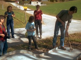
Miniature Golf Hiking Trail
Path number: 3,6,10
Starting place: 4574 Vorderstoder
Destination: 4574 Vorderstoder
The hiking mini-golf trail with a new route and a length of approx. 3.5 km is unique in Austria!
Our mini-golf hiking trail should be a nice incentive for you to walk a trail more than once. You get club and ball for a price of € 8.00. This equipment is now your property and you can of course start a new round on your next visit!!!
With the Pyhrn-Priel-AktivCard you receive the equipment for mini-golf on loan free of charge.
Walking time: approx. 1 hr.
Refreshment stops: Dorfliebe, Bergpfeffer
Path number: 3,6,10
Starting place: 4574 Vorderstoder
Destination: 4574 Vorderstoder
duration: 1h 0m
length: 3,5 km
difficulty: easy
condition: easy
panoramic view: Great panorama
Paths covering:
Asphalt, Hiking trail
Starting point: Landhotel Stockerwirt Vorderstoder
Destination: Landhotel Stockerwirt Vorderstoder
further information:
- Flatly
- Board possible
Details - hiking
- themed path
Station 10
Station 2
Station 3
Station 4
Station 5
Station 6
Station 7
Station 8
Station 9
Accessibility / arrival
by car:
Motorway A1 to A9, exit Voralpenkreuz Hinterstoder, country road to Hinterstoder - 200 meters after the sign Hinterstoder turn left to Vorderstoder (approx 5 km).
by train:
Pyhrnbahn stop Windischgarsten (10 km) or Hinterstoder (15 km) -> from the City
Most economical season
- Summer
Please get in touch for more information.
Vorderstoder 66
4574 Vorderstoder
Phone +43 7564 8255
Fax machine +43 7564 8255 - 20
E-Mail vorderstoder@pyhrn-priel.net
Web www.urlaubsregion-pyhrn-priel.at
https://www.urlaubsregion-pyhrn-priel.at


