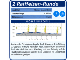
Raiffeisen-Round
Starting place: 4864 Attersee am Attersee
Destination: 4864 Attersee am Attersee
Attergaustraße 55
4880 St. Georgen im Attergau
4880 St. Georgen im Attergau

Start: Christophorus chapel | Blue mark
Starting place: 4864 Attersee am Attersee
Destination: 4864 Attersee am Attersee
duration: 2h 21m
length: 8,9 km
Altitude difference (uphill): 103m
Altitude difference (downhill): 103m
Lowest point: 471m
Highest point: 545m
difficulty: very easy
condition: medium
panoramic view: Great panorama
Paths covering:
Asphalt
Starting point: Attersee - Christophorus chapel
Destination: Attersee - Christophorus chapel
further information:
- Flatly
- Board possible
all year
Accessibility / arrival
By car:
From Salzburg take the motorway A1 – exit St. Georgen im Attergau – left sight Attersee
From Vienna/Linz take motorway A1 – exit St. Georgen im Attergau – left sight Attersee
From Westside – Bad Ischl – Weißenbachtal – Unterach – Nußdorf – Attersee
By train:
From Salzburg or Vienna/Linz to Vöcklamarkt, change the ÖBB-train to Attergaubahn to Attersee
By airplane:
From Salzburg take the motorway A1 – exit St. Georgen im Attergau – left sight Attersee
From Vienna/Linz take the motorway A1 – exit St. Georgen im Attergau – left sight Attersee
- Parking space: 5
General price information
free
- All weather
- Suitable for groups
- Suitable for schools
- Suitable for teenagers
- Suitable for seniors
- Suitable for single travelers
- Suitable for families
- Suitable for friends
- Suitable for couples
- Suitable for children
- Spring
- Summer
- Autumn
- Early winter
Please get in touch for more information.
Attergaustraße 55
4880 St. Georgen im Attergau
Phone +43 7666 7719
E-Mail info@attersee.at
Web www.attersee.ooe.gv.at
Web attersee-attergau.salzkammergut.at
http://www.attersee.ooe.gv.at
https://attersee-attergau.salzkammergut.at
https://attersee-attergau.salzkammergut.at
You can also visit us on
Facebook YouTube Wikipedia Blog


