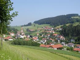
Rundblickeweg in Guttenbrunn
Starting place: 4242 Hirschbach im Mühlkreis
Destination: 4242 Hirschbach im Mühlkreis
A circular route between Gasthaus Dunzinger and the Kulturwirtshaus Pammer, also accessible with pushchairs (only 100m difference in altitude).
Natural paths, very few wooded areas, mostly high plateau with wonderful views. From the "Luag" viewing point (781m) you can enjoy a panoramic view of the eastern Mühlviertel.
Natural paths, very few wooded areas, mostly high plateau with wonderful views. From the "Luag" viewing point (781m) you can enjoy a panoramic view of the eastern Mühlviertel.
Accessibility / arrival
Arrival by car:
From Linz via the A7 (Mühlkreis motorway) towards Prague/Freistadt as far as Unterweitersdorf, then turn left after the end of the motorway (towards Prague/Freistadt) and continue on the B125 to Freistadt. In Freistadt turn left towards Bad Leonfelden (B38). After approx. 1 km, turn left again towards Hirschbach.
Travelling by train:
Take the train from Linz main station, change there to the Linz-Summerau line, get off at Trölsberg (train station near Freistadt).
- Parking space: 20
- Bus parking space: 1
- Suitable for groups
- Suitable for schools
- Suitable for pushchairs
- Pets allowed
- Spring
- Summer
- Autumn
Please get in touch for more information.
Museumsweg 6
4242 Hirschbach im Mühlkreis
Phone +43 7948 55895
E-Mail info@kraeuterkraftquelle.at
Web www.kraeuterkraftquelle.at
http://www.kraeuterkraftquelle.at
powered by TOURDATA


