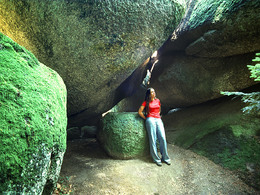
Zigeunermauern S7
Path number: S7
Starting place: 4364 St. Thomas am Blasenstein
Destination: 4364 St. Thomas am Blasenstein
Markt 7
4364 St. Thomas am Blasenstein
4364 St. Thomas am Blasenstein

Where eye ailments are cured and where the robber chief once lived.
Through the centre of the village (the Wackelstein can be visited 50 m from the path at Markt 26) to the entrance to the village. Then turn left along the pavement along the road, you can visit the Phallus stone off the road, as far as the tennis centre. There turn left through the forest, after a climb you reach a farm vulgo Hinterholzer Ober St. Thomas 31. Turn left in front of the house, then right again into the forest. Continue to a road on the left and at the farmhouse vulgo Kaufrechter turn right before the house on the goods road to the end. Then through the forest, in the municipality of Pierbach you will discover the Augenbründl. Pass the Augenbründel on the left, then turn right up the fork in the path. Ascend through the forest to a goods road, cross it and continue straight up to the gypsy walls. Then descend to the left, continue along the farm track, then turn right back into the forest past the Langgruber farmhouse. Turn right along the road and left past the chapel. Immediately afterwards, the path turns right again into the Domkapitelwald forest. Then briefly on the goods road to the country road, along this to the left briefly to the Ploama access road. Turn right up this road and before the house turn left back into the forest to the sports centre. Follow the footpath into the village. Path number: S7
Starting place: 4364 St. Thomas am Blasenstein
Destination: 4364 St. Thomas am Blasenstein
duration: 2h 42m
length: 8,3 km
Altitude difference (uphill): 314m
Altitude difference (downhill): 320m
Lowest point: 560m
Highest point: 727m
difficulty: difficult
condition: medium
panoramic view: Great panorama
Paths covering:
Asphalt, unfixed, Hiking trail
Starting point: Market town hall
Destination: Market town hall
further information:
- Flatly
- Board possible
all year round but no snow clearance
Accessibility / arrival
by car:
Highway exit Ybbs, Amstetten or Enns
Ybbs - Grein - St. Thomas am Bl.
Amstetten - Grein - St. Thomas am Bl.
Linz - Mauthausen - Perg - Münzbach - St Thomas am Bl.
by train:
By train to Perg and Grein and then approx. 14 km by post bus to St. Thomas am Bl.
General price information
Hiking map of the Mühlviertel Nature Park (municipalities: Allerheiligen, Bad Zell, St. Thomas, Rechberg) available for € 2.00 at the market town office, inn Ahorner, Doll's House Museum and at Nah & Frisch.
- All weather
- Suitable for groups
- Suitable for schools
- Pets allowed
- Suitable for teenagers
- Suitable for families
- Suitable for friends
- Suitable for couples
- Spring
- Summer
- Autumn
Please get in touch for more information.
other information
- Toilet facility for disabled people
Markt 7
4364 St. Thomas am Blasenstein
Phone +43 7265 5455
E-Mail marktgemeinde@st-thomas.at
Web www.st-thomas.at
http://www.st-thomas.at


