355 Cycle tour "Weitblick"
Fitness circuit - panoramic view
At 488 metres, the Gustermairberg is the highest elevation in the municipality of Kremsmünster - that's exactly where we want to go and we use an energy-saving route west of Adlwang via Weißenbach for the ascent. The following seven kilometres to our destination for the day are pleasantly flat with a wonderful view of the eastern edge of the Krems Valley.
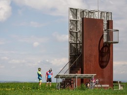
The "tree in the middle of the world" itself is the crowning glory of the tour and dates back to Emperor Franz the First - the cadastral survey of several crown lands began here in 1823, and a small observation tower provides more detailed information. The "tree" was an old mighty lime tree until 1929. The current lime tree has stood here since 1916.
The harmonious atmosphere then rolls effortlessly down into the Sulzbach valley on the way home, the eyes and mind draw inspiration from nature, the body relaxes contentedly.
Route:
Eduard-Bach-Straße - Föding - Sitzleinsdorf - Weißenbach - Ehrndorf - Mayrhof - Baum mitten in der Welt - Krühub - Feyregg - Eduard-Bach-Straße
Character of the route:
Cycle route on quiet side roads without any significant gradients, also suitable for untrained cyclists.
Suitable for the whole family and for racing cyclists.
- Suitable for groups
- Suitable for schools
- Suitable for teenagers
- Suitable for seniors
- Suitable for single travelers
- Suitable for families
- Suitable for friends
- Suitable for couples
- Spring
- Summer
- Autumn
Please get in touch for more information.
Kurpromenade 1
4540 Bad Hall
Phone +43 7258 7200
E-Mail info@bts-tourismus.at
Web www.badhall.at


