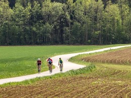
353 Cycle tour "Mostradler"
Cycle path on quiet side roads without any significant gradients, also manageable for the untrained.
Out of the city and into the countryside - after a section of cycle path next to the B122, it soon becomes quiet and rural. A short, distinctive ascent and you are already cycling easily with a magnificent view between farmsteads and orchards - typical of our region are groups or flocks of apple and pear trees.
apple and pear trees. Without them, nature would be empty - at blossom time, they characterise the countryside as oversized flowering bushes. They are important habitats for wildlife, slow down the harsh winds and in autumn the fruit is used to produce the "Landessäure", or cider. However, it takes a lot of work and knowledge before the delicious golden yellow drink in various degrees of alcohol is served alongside a tasty snack - the term "Mostschädeln" (cider skulling) is not meant in a bad way for locals. Of course, the characteristic drink is also served; halfway along the route, a tasting is recommended in Großmengersdorf to recharge your batteries for the climb out of the Haselbachsenke. The Aumühle mill in the Sulzbach valley is reminiscent of earlier times with small mills along lively streams, almost all of which had to make way for industrial production ... but the cider has remained!
Path:
Eduard-Bach-Straße - Hauptplatz - Eggmair - Steinersdorf - Katzenmarkt - Pesendorf - Großmengersdorf - Haselmayer - Auhuber - Eduard-Bach-Straße.
- Suitable for groups
- Suitable for schools
- Suitable for families
- Spring
- Summer
- Autumn
Please get in touch for more information.
Kurpromenade 1
4540 Bad Hall
Phone +43 7258 7200
E-Mail info@bts-tourismus.at
Web www.badhall.at


