13 St. Blasien Rundwanderweg
Starting place: 4540 Bad Hall
Destination: 4540 Bad Hall
Kurpromenade 1
4540 Bad Hall
4540 Bad Hall

Route: Eduard-Bach-Straße (Museum Forum Hall) - Kurhaus - Kurpromenade - Gh. Lamplhub - Eglseer - Breidheider - Siedlung - Kirche St. Blasien - Mangstmühle - Hieslhofer - Ortmühle - Agru-Werk - Grünburger/Adlwanger-Kreuzung - Steyrer Straße - Hauptplatz - Eduad-Bach-Straße.
Destination: St. Blasien (walking time approx. 1 hour 15 minutes)
Panorama square: Lamplhub, Hieslhofer, Grillmayr
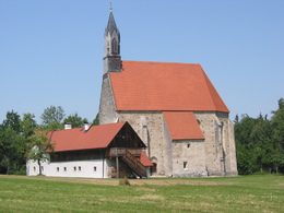
Tip: St. Blasien church
(More information about St. Blasien church: https://www.badhall.at/oesterreich-poi/detail/430011825/filialkirche-st.-blasien-mit-mesnerhaeusl.html
Refreshment stop: Gh. Lamplhub
Panoramic square: Lamplhub, Hieslhofer, Grillmayr
Tip: Church of St. Blasien
(Further information on the St. Blasienkirche: https://www.badhall.at/oesterreich-poi/detail/430011825/filialkirche-st.-blasien-mit-mesnerhaeusl.html)
Possibility of refreshment: Gh. Lamplhub
- Suitable for groups
- Suitable for schools
- Pets allowed
- Spring
- Summer
- Autumn
Please get in touch for more information.
Kurpromenade 1
4540 Bad Hall
Phone +43 7258 7200
E-Mail info@bts-tourismus.at
Web www.badhall.at
https://www.badhall.at


