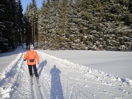
© Photo: Oberösterreich Tourismus GmbH./Robert Maybach: Enjoy the view in Upper Austria
Enjoy the view in Upper Austria
Search
Search
Close

Sonnenloipe Hellmonsödt-Sonnberg 4 km

  • Suitable for families
  • Flatly

 Interactive elevation profile

Download GPS data
Create PDF

Tour-Details

Starting place: 4202 Hellmonsödt
Destination: 4202 Hellmonsödt

duration: 1h 15m
length: 7,6 km
Altitude difference (uphill): 159m
Altitude difference (downhill): 136m

Lowest point: 807m
Highest point: 868m
difficulty: easy
condition: medium
panoramic view: Great panorama

Paths covering:
snow

powered by TOURDATA

Trail not in operation
Hellmonsödt lies at an altitude of 824 metres above sea level and is therefore a paradise for cross-country skiers thanks to its reliable snow conditions. 14 kilometres of perfectly groomed cross-country trails and the fresh winter air offer both beginners and advanced skiers an excellent opportunity to pursue their hobby.
Parking
  • Parking space: 100
Travelling by public transport
Route planner for independent travellers
  • Suitable for groups
  • Suitable for schools
  • Suitable for teenagers
  • Suitable for seniors
  • Suitable for single travelers
  • Suitable for friends
  • Suitable for couples
Most economical season
  • Early winter
  • Deep winter

Please get in touch for more information.


Sonnenloipe Hellmonsödt-Sonnberg 4 km
L(i)ebenswertes Hellmonsödt
Marktplatz 1
4202 Hellmonsödt

Phone +43 7215 2255 - 0
E-Mail gemeinde@hellmonsoedt-zwettl.at
Web www.hellmonsoedt.ooe.gv.at/
http://www.hellmonsoedt.ooe.gv.at/

We speak the following languages

German

 Interactive elevation profile

Download GPS data
Create PDF

Tour-Details

Starting place: 4202 Hellmonsödt
Destination: 4202 Hellmonsödt

duration: 1h 15m
length: 7,6 km
Altitude difference (uphill): 159m
Altitude difference (downhill): 136m

Lowest point: 807m
Highest point: 868m
difficulty: easy
condition: medium
panoramic view: Great panorama

Paths covering:
snow

powered by TOURDATA