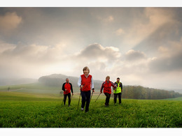
Lebensquell Nordic-Walking-Runde Nr. 10
Starting place: 4283 Bad Zell
Destination: 4283 Bad Zell
Lebensquellplatz 1
4283 Bad Zell
4283 Bad Zell

The challenging route leads to Riegl via the Ortner sawmill to the neighbouring village of Tragwein. At the lower market square, turn left towards Bad Zell.
Please note: always follow the yellow Lebensquell Nordic Walking markings.
Return via Waltersberg past the Langebner Hütte cider tavern and Kapferberger cider tavern.
Langebner Hütte, Mayrhofer family, 0664/2041081 - open Fri, Sat, Sun and public holidays from 2 pm
Please note: always follow the yellow Lebensquell Nordic Walking markings.
Return via Waltersberg past the Langebner Hütte cider tavern and Kapferberger cider tavern.
Langebner Hütte, Mayrhofer family, 0664/2041081 - open Fri, Sat, Sun and public holidays from 2 pm
Starting place: 4283 Bad Zell
Destination: 4283 Bad Zell
duration: 3h 30m
length: 13,0 km
Altitude difference (uphill): 364m
Altitude difference (downhill): 359m
Lowest point: 412m
Highest point: 576m
difficulty: medium
condition: medium
panoramic view: Some Views
Paths covering:
Asphalt, Hiking trail
Starting point: directly at the Lebensquell health centre / primary school car park
further information:
- Flatly
Information at the tourist office or at the Lebensquell Centre
Accessibility / arrival
by car:
Vienna: A1 exit Enns-Mauthausen-Perg (14km)-Bad Zell
Linz: A7-Unterweitersdorf-Pregarten-Tragwein-Bad Zell
by train:
Vienna: Linz (train) from Linz with the Postbus to Bad Zell - 40 km; or to Pregarten by train - 20 km to Bad Zell
Most economical season
- Spring
- Summer
- Autumn
Please get in touch for more information.
Lebensquellplatz 1
4283 Bad Zell
Phone +43 5 07263 - 0
E-Mail badzell@muehlviertel.at
Web www.kulturforum-badzell.at
https://www.kulturforum-badzell.at


