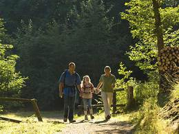
© Photo: Oberösterreich Tourismus GmbH./Robert Maybach: Enjoy the view in Upper Austria
Enjoy the view in Upper Austria
search
Search
Close

Keltenweg

 Interactive elevation profile

Download GPS data
Create PDF

Tour-Details

Starting place: 5221 Lochen
Destination: 5221 Lochen

duration: 2h 10m
length: 7,9 km
Altitude difference (uphill): 128m
Altitude difference (downhill): 127m

Lowest point: 514m
Highest point: 581m
difficulty: medium
condition: medium
panoramic view: Some Views

Paths covering:
Street, Hiking trail, Other

powered by TOURDATA

The trail leads from Lochen via Intenham to Stullerding (Süßpoint district) to the best-preserved Celtic redoubt (Celtic cult site) in southern Germany. This trail also leads to the Dreifaltigkeitsmarterl (from the 17th century), to the Heimkehrerkapelle chapel in Flörlplain. Return via the villages of Kranzing (marvellous views) Gunzing and Koppelstätt to Lochen (approx. 8 km).
Travelling by public transport
Route planner for independent travellers
Most economical season
  • Spring
  • Summer
  • Autumn

Please get in touch for more information.


Keltenweg
Entdeckerviertel
Theatergasse 3
5280 Braunau am Inn

Phone +43 7722 62644
E-Mail info@entdeckerviertel.at
Web www.entdekcerviertel.at
Web www.lochen.at
http://www.entdekcerviertel.at
http://www.lochen.at

We speak the following languages

German

 Interactive elevation profile

Download GPS data
Create PDF

Tour-Details

Starting place: 5221 Lochen
Destination: 5221 Lochen

duration: 2h 10m
length: 7,9 km
Altitude difference (uphill): 128m
Altitude difference (downhill): 127m

Lowest point: 514m
Highest point: 581m
difficulty: medium
condition: medium
panoramic view: Some Views

Paths covering:
Street, Hiking trail, Other

powered by TOURDATA