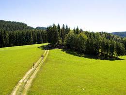
Wanderweg Römerweg
Starting place: 4754 Andrichsfurt
Destination: 4754 Andrichsfurt
Hiking trail Römerweg (duration approx. 2 hours)
Set off from the centre of Andrichsfurt in the direction of the sports field. Cross the main road and follow the path through the Andrichsfurt wood. After approx. 600 metres you come to the so-called Römerweg, which you follow to the left towards Stelzer as far as the chapel. (You can stop for refreshments at the "Moar Sepp" inn). From here you walk along the Höhenstraße to Murau. In Murau, turn left towards Steingreß. At the Bauer z'Steingreß farm you come to the Krammern farm track. Turn right here towards Pötting (refreshments available at the Stockenhuber inn), cross the main road and return to the starting point.
Set off from the centre of Andrichsfurt in the direction of the sports field. Cross the main road and follow the path through the Andrichsfurt wood. After approx. 600 metres you come to the so-called Römerweg, which you follow to the left towards Stelzer as far as the chapel. (You can stop for refreshments at the "Moar Sepp" inn). From here you walk along the Höhenstraße to Murau. In Murau, turn left towards Steingreß. At the Bauer z'Steingreß farm you come to the Krammern farm track. Turn right here towards Pötting (refreshments available at the Stockenhuber inn), cross the main road and return to the starting point.
- All weather
- Suitable for groups
- Suitable for seniors
- Suitable for families
- Spring
- Summer
- Autumn
Somewhat suitable for wheelchairs: Assistance is sometimes necessary. The measurements do not (fully) conform to the legally stipulated ÖNORM.
Andrichsfurt 40
4754 Andrichsfurt
Phone +43 7750 3213
E-Mail gemeinde@andrichsfurt.ooe.gv.at
Web www.andrichsfurt.at
http://www.andrichsfurt.at


