Naturfreundeweg zum Salzachdurchbruch
Starting place: 5122 Hochburg-Ach
Destination: 5122 Hochburg-Ach
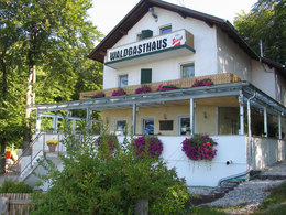
The "Friends of Nature Hiking Trail" starts at the Friends of Nature clubhouse and forest inn.
At the beginning, it runs a short distance through a 120-year-old forest.After overcoming a short steep section, you reach the highest point of the trail. From this plateau, there is a view of the steeply rising gravel walls on the Bavarian side of the Salzach. These were formed during the last ice age "Würm period" around 20,000 to 30,000 years ago.
The forest in this section consists mainly of various deciduous trees, predominantly natural beech.
The trail continues over a natural stone bridge consisting of underwashed conglomerate (Nagelfluh) - this section of the trail is popularly known as the "Keltenburg" (Celtic castle) - through the low mixed forest and finally downhill into the spruce forest that was afforested after the Second World War.
Here the hiking trail joins the forest road leading downhill to a long-established hollow path covered by hardwoods. The path then leads along the forest road into the alluvial forest near the Salzach.
You now walk directly along the banks of the Salzach on a fairly level stretch to a small clearing from where you can see the Salzach and a large part of the Bavarian bank. Hikers cannot miss the so-called "Kreuzfelsen" here. This is a boulder the size of a house, consisting of Nagelfluh, which was pushed into the river bed by the melt water from the glacial and glacial periods. It may well have been a fearsome obstacle for the Salzach boatmen and raftsmen at the time.
After contemplating the beautiful river landscape, which has been spared any artificial intervention in nature, the hiking trail leads through strips of alluvial forest with some remarkable tree species. The narrow path continues through the Augehölz, along a slope, until you finally reach the end point of the hiking route.
This is a large stone dam, known as a "dog", "wolf" or "spur" in the local dialect, which was built in 1923 after a massive flood.
Most economical season
- Spring
- Summer
- Autumn
- Early winter
Please get in touch for more information.
Theatergasse 3
5280 Braunau am Inn
Phone +43 7722 62644
E-Mail info@entdeckerviertel.at
Web www.entdeckerviertel.at
http://www.entdeckerviertel.at


