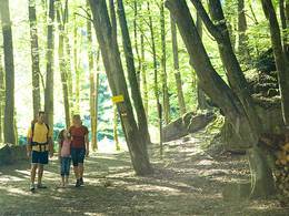
© Photo: Oberösterreich Tourismus GmbH./Robert Maybach: Enjoy the view in Upper Austria
Enjoy the view in Upper Austria
search
Search
Close

Gaspoltshofener Rundweg Lenglachwald

  • Suitable for families
  • Suitable for kids (all ages)

 Interactive elevation profile

Download GPS data
Create PDF

Tour-Details

Starting place: 4674 Gaspoltshofen
Destination: 4674 Gaspoltshofen

duration: 0h 45m
length: 3,0 km
Altitude difference (uphill): 21m
Altitude difference (downhill): 23m

Lowest point: 498m
Highest point: 534m
difficulty: very easy
condition: very easy
panoramic view: Great panorama

Paths covering:
Gravel, Street, Hiking trail

powered by TOURDATA

The Lenglach circular trail leads through Altenhof and the Lenglach forest.

The start/finish is the church square in Altenhof. You walk along the road in the direction of Epfenhofen and walk along the "Waldspitz" along the Lenglach forest past a few viewing benches that invite you to linger.
The signposts show you the way through the forest to Lenglach, where you return to the starting point along the road.
Parking
  • Parking space: 20
  • Parking area for disabled: 2
  • Bus parking space: 2
Travelling by public transport
Route planner for independent travellers
  • Suitable for groups
  • Suitable for schools
  • Suitable for kids (all ages)
  • Suitable for teenagers
  • Suitable for seniors
  • Suitable for single travelers
  • Suitable for families
  • Suitable for friends
  • Suitable for couples
  • Suitable for children
Most economical season
  • Spring
  • Summer
  • Autumn

Somewhat suitable for wheelchairs: Assistance is sometimes necessary. The measurements do not (fully) conform to the legally stipulated ÖNORM.

other information
  • Toilet facility for disabled people

Gaspoltshofener Rundweg Lenglachwald
Rundweg Lenglachwald
Altenhof, Epfenhofen, Lenglach
4673 Gaspoltshofen

Phone +43 7735 6954
Fax machine +43 7735 6954 - 33
E-Mail gemeinde@gaspoltshofen.ooe.gv.at
Web www.gaspoltshofen.at
http://www.gaspoltshofen.at

We speak the following languages

German

 Interactive elevation profile

Download GPS data
Create PDF

Tour-Details

Starting place: 4674 Gaspoltshofen
Destination: 4674 Gaspoltshofen

duration: 0h 45m
length: 3,0 km
Altitude difference (uphill): 21m
Altitude difference (downhill): 23m

Lowest point: 498m
Highest point: 534m
difficulty: very easy
condition: very easy
panoramic view: Great panorama

Paths covering:
Gravel, Street, Hiking trail

powered by TOURDATA