Character: High alpine mountain tour with several exposed but well-secured rock passages. Sure-footedness and a head for heights are necessary; do not go in fog or snow!
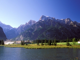
The history of mountain development not only records aristocrats and alpine heroes: In the Totes Gebirge, it also immortalises the Wels tax official Sepp Huber, who at the beginning of the 20th century, when the Totes Gebirge was still a hermetically sealed hunting ground, cleared the north-facing access routes for mountaineers and secured them with iron. However, you still need to be in good physical condition and have good weather conditions to scramble up from the Almsee to the vast and desolate plateau of the mountain range. The mighty limestone peaks between the Rotgschirr and the Woising, which once served as a natural sun chronometer for the Almtal farmers, should only be approached when the last snow has given way to the first blossoms. Our tour begins on the forest road that leads from the southern shore of the Almsee into the deeply incised rocky basin of the "Röll". Where does this strange name come from? During storms, the rubble that the surrounding rocky gorges spew out in masses crashes down here. We soon branch off to the left onto the Sepp-Huber-Steig (signpost no. 214). With the help of steel ropes and ladders, you overcome the rock steps of the Ahorn cirque, which is still forested in places. At the top of the Röllsattel, the karst plateau lies before you as if with a bang. At the foot of the mesa-like Rotgschir, which can also be crossed on a secured path, you cross it to the Ausseer Weg (no. 201), which leads to the Pühringerhütte on the right. A challenging descent is possible via the primeval Grießkarscharte: Take trail no. 201 in the direction of Ausseerland, past the Elmsee lake and into the Elmgrube. Turn right there, climb up to Abblasbühel and behind it, on the "Wiesen", follow path no. 213 to the right into the Steinöde. In the primeval landscape of the Grießkarscharte, between the Elfer- and Zwölferkogel, you can expect huge slabs of rock and snow well into the summer. Behind this, you have to use steel cables and a ladder to climb down into the unstable depths - the impression of this steep rocky landscape is overwhelming. This is followed by a long steep descent into the Röll, then the route continues along the familiar forest road to the Almsee lake.
The tours presented here are suggested tours that are provided free of charge. After agreeing to the terms of the disclaimer you receive detailed information such as altitude profiles, route plans, and an option for downloading files etc.
Please click on the button "Create PDF now" to generate the document.
Loading...
Thank you for your interest, we are generating the document for you. This may take a while. Once the PDF has finished loading, it will open in a new window. The pop-up blocker of your browser should be disabled for our site.