

Over the corne up to Miglberg


Interactive elevation profile
Create PDF
Tour-Details
Starting place: 4852 Weyregg am Attersee
Destination: 4852 Weyregg am Attersee
duration: 1h 5m
length: 2,8 km
Altitude difference (uphill): 227m
Lowest point: 478m
Highest point: 705m
difficulty: medium
condition: medium
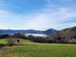
panoramic view: Great panorama
Paths covering:
Asphalt, Hiking trail, Other
powered by TOURDATA
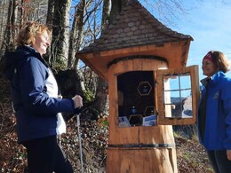
An entertaining hike on two mountains with a panoramic view and the opportunity to stop off at the Schöberingerhof inn on the Miglberg
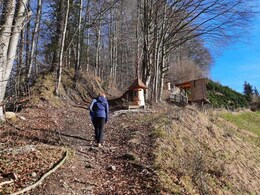
The starting point for this round trip is on fire station in the center of Weyregg. We pass the church, walk up to the Rosenrundeau and then follow the signs to Bach Miglberg.By the Stegbühel we go down the stairs into the Bachtal. After crossing the creek Weyregger, we follow the yellow signs to the Miglberg.
This path ascends up to 713 m high and we may enjoy a splendid view from the ridge. Then we pass the Lenznmannhof and hike up to the inn on Schöberingerhof. Here we can refresh ourselves by the lake. From there we move on to the Hasenbach Foedinger. Again, we have the opportunity for a short rest. Afterwards, we continue along the creek valley road on to the access road Schmaußing / Miesberg. We walk uphill and turn right before the Schmaussingerhof. A meadow path leads us along the creek after Mies Bruckbach. During this section it opens up again and we are treated to a magnificent viewsof the lake Attersee once more. From Bruckbach we finally return from the woodland realm to Weyregg Auweg back. Here, we can find our way back into the valley.
Most economical season
- Spring
- Summer
- Autumn
Please get in touch for more information.
")
Weyreggerstrasse 69
4852 Weyregg am Attersee
Phone +43 7666 7719 - 70
E-Mail info.weyregg@attersee.at
Web attersee-attergau.salzkammergut.at
https://attersee-attergau.salzkammergut.at
You can also visit us on
Visit us on Facebook Visit our videochannel on YouTube WikipediaInteractive elevation profile
Create PDF
Tour-Details
Starting place: 4852 Weyregg am Attersee
Destination: 4852 Weyregg am Attersee
duration: 1h 5m
length: 2,8 km
Altitude difference (uphill): 227m
Lowest point: 478m
Highest point: 705m
difficulty: medium
condition: medium
panoramic view: Great panorama
Paths covering:
Asphalt, Hiking trail, Other
powered by TOURDATA