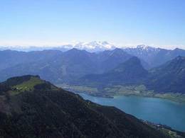
Schafberg (sheep mountain) - Purtschellersteig
Starting place: 5310 St. Lorenz am Mondsee
Destination: 5310 St. Lorenz am Mondsee
Dr. Franz Müller Straße 3
5310 St. Gilgen
5310 St. Gilgen

Once up to the Schafberg (sheep mountain) inkluding a circular trail visiting three mountain lakes.
Attention: alpine experience strongly recommended!From the parking in the district of Scharfling on the way from the Mondsee to the Wolfgangsee lake the tour is started by following the hiking trail through the forest to the Kesselalm. After another hour of increasing you reach the Schafbergalm (sheep mountain alp). From now follow the trail to the Schafberg (sheep mountain) peak until you reach a crossing by the tracks of the Schafberg train. Take the trail signed with "Purtschellersteig". After a short section secured with ropes you reach two mountain lakes called "Mönichsee" and "Mittersee". When reached the third lake called "Suissensee" you follow the trail to the "Himmelspforte" (heaven's gate) back to the Schafberg summit.
As an alternative you may descend via the Eisenau Alp back to the starting point.
One who does not want to climb from the starting point can use the cog railway leading to the Schafberg peak and start the tour from here. Be warned that alpine experience is recommended anyway.
Most economical season
- Summer
- Autumn
Please get in touch for more information.
Dr. Franz Müller Straße 3
5310 St. Gilgen
Phone +43 6232 2270
Fax machine +43 6232 2270 - 22
E-Mail info@mondsee.at
Web mondsee.salzkammergut.at
https://mondsee.salzkammergut.at


