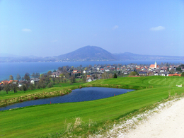
© Photo: Oberösterreich Tourismus GmbH./Robert Maybach: Enjoy the view in Upper Austria
Enjoy the view in Upper Austria
search
Search
Close

small Hochkreuthway

  • All weather
  • Suitable for kids (all ages)
  • Flatly

 Interactive elevation profile

Download GPS data
Create PDF

Tour-Details

Starting place: 4852 Weyregg am Attersee
Destination: 4852 Weyregg am Attersee

duration: 0h 57m
length: 3,3 km
Altitude difference (uphill): 81m
Altitude difference (downhill): 81m

Lowest point: 477m
Highest point: 537m
difficulty: easy
condition: easy
panoramic view: Great panorama

Paths covering:
Gravel, Hiking trail

powered by TOURDATA

Small Hochkreuthweg trail along the golf course with panoramic views.

Start at the car park opposite the church next to the fire station/musicians' home in the direction of Wachtberg. About 300 metres later, turn right onto Hochkreuthweg. At the next fork in the road, turn right again. Now follow the path until you reach Dr Gleißnerweg in Buchschacher. Keep right here and you will pass the See-Alpakagehege and return to Weyregg. Caution: as you are on the edge of the golf course, you should pay attention to the golfers' warning call, namely "VOR".

Refreshments:
Restaurant at the golf course  - Pizzeria Avocado
Parking
  • Parking space: 60
Travelling by public transport
Route planner for independent travellers
  • All weather
  • Suitable for kids (all ages)
Most economical season
  • Spring
  • Summer
  • Autumn
  • Early winter

Please get in touch for more information.


small Hochkreuthway
TVB Attersee - Attergau
Steinbach 5
4853 Steinbach am Attersee

Phone +43 7666 7719 - 70
E-Mail info.weyregg@attersee.at
Web attersee-attergau.salzkammergut.at
https://attersee-attergau.salzkammergut.at

You can also visit us on

Visit us on Facebook Visit our videochannel on YouTube Wikipedia

We speak the following languages

German

 Interactive elevation profile

Download GPS data
Create PDF

Tour-Details

Starting place: 4852 Weyregg am Attersee
Destination: 4852 Weyregg am Attersee

duration: 0h 57m
length: 3,3 km
Altitude difference (uphill): 81m
Altitude difference (downhill): 81m

Lowest point: 477m
Highest point: 537m
difficulty: easy
condition: easy
panoramic view: Great panorama

Paths covering:
Gravel, Hiking trail

powered by TOURDATA