Trattberg - Loizenwies - Hongar
4880 St. Georgen im Attergau

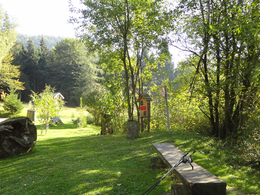
This scenic hike takes us via Loizenwies to the 943 m high Hongar in Aurach, from where there is a wonderful view over the region. The hike, which partly leads through the forest, is an experience in summer and winter.
Return via the ascent route back to Schörfling to the starting point at the Kaufhaus Freund/Oberhehenfeld parking lot. The total walking time here is about four hours.
Variant 1:
From Hongar you can also hike directly down to Aurach. Since there is no connection with a public transport from here, there is the possibility to take a cab or also to hike on foot to Schörfling. In this case, the total walking time is 3.5 hours.
Variant 2:
If you want to hike a bit further, you go back from Hongar via the Höhenweg as well as the Alpenberg to the Gahberg. From there you can descend via the Häfelberg back to Schörfling. The total walking time here is about 3.5 hours.
Refreshment stop:
Almgasthof Schwarz, Hongar - Tel. +43 7662 2012.
Other places to stop for refreshments are here.
Paths covering:
further information:
- Board possible
Car:
From Salzburg via the A1 - exit Seewalchen
From Vienna/Linz via A1 - exit Schörfling or Seewalchen
From the west - Bad Ischl-Weißenbach-Steinbach-Weyregg-Schörfling
By train:
Coming from Salzburg or Linz/Vienna to Attnang-Puchheim or Vöcklabruck - continue with the Kammer Bahn to BH Kammer Schörfling or with the bus stop Kammer-Agerbrücke or Seewalchen-Agerbrücke.
Plane:
From Salzburg via A1 - exit Seewalchen
From Vienna/Linz via A1 - exit Schörfling or Seewalchen
Coming from Schörfling to Gmundnerstraße until the bypass - right bypass direction Kammer - turn left to Oberhehenfeld - Kaufhaus Freund, Sickingerstraße
Parking possibility directly at the former department store Freund in Sicking.
- Parking space: 10
- All weather
- Suitable for groups
- Suitable for schools
- Suitable for kids (5 - 14 Year)
- Pets allowed
- Suitable for teenagers
- Suitable for seniors
- Suitable for single travelers
- Suitable for families
- Suitable for friends
- Suitable for couples
- Suitable for children
- Spring
- Summer
- Autumn
- Early winter
Please get in touch for more information.
Attergaustraße 55
4880 St. Georgen im Attergau
Phone +43 7666 7719 - 0
Fax machine +43 7666 7719 - 19
E-Mail info.schoerfling@attersee.at
Web attersee-attergau.salzkammergut.at
You can also visit us on
Facebook YouTube Wikipedia


