Jagahäusl to the Blumaueralm
Starting place: 4581 Rosenau am Hengstpaß
Destination: 4591 Molln
Bahnhofstraße 2
4580 Windischgarsten
4580 Windischgarsten

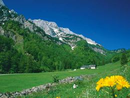
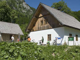
Hike the cozy way of Jagahäusl in Bodinggraben at Molln to Blumaueralm.
From the Jagahäusl tavern walk along a gentle rising forest road along the Blöttenbach stream to the idyllic Blumaueralm, an alpine meadow and pasture (not managed).This path is also suitable as a jogging and nordic walking trail.
Walking Time: 45 min.
Altitudes: 641 - 762m above sea-level
Starting place: 4581 Rosenau am Hengstpaß
Destination: 4591 Molln
duration: 1h 22m
length: 3,6 km
Altitude difference (uphill): 239m
Altitude difference (downhill): 113m
Lowest point: 638m
Highest point: 790m
difficulty: easy
condition: easy
panoramic view: No view
Paths covering:
Asphalt, Gravel, Street
Starting point: Jagahäusl in Bodinggraben at Molln in the municipality of Rosenau Hengstpaß
Destination: Blumaueralm in the Limestone Alps National Park
further information:
- Board possible
Accessibility / arrival
Molln - Breitenau - Bodinggraben
Parking feesno
- Suitable for pushchairs
- Spring
- Summer
- Autumn
- Early winter
Please get in touch for more information.
Bahnhofstraße 2
4580 Windischgarsten
Phone +43 7562 5266
Fax machine +43 7562 5266 - 10
E-Mail info@pyhrn-priel.net
Web www.urlaubsregion-pyhrn-priel.at
https://www.urlaubsregion-pyhrn-priel.at


