

MTB Tour Ennser Hütte


- culinary interesting
- Possible accommodation
Interactive elevation profile
Create PDF
Tour-Details
Starting place: 4463 Großraming
Destination: 4463 Großraming
duration: 4h 9m
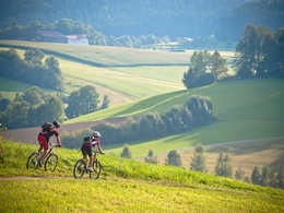
length: 23,4 km
Altitude difference (uphill): 1.015m
Altitude difference (downhill): 1.015m
Lowest point: 375m
Highest point: 1.330m
difficulty: medium
condition: medium
panoramic view: Dreamtour
Paths covering:
Asphalt, Path / trail, Gravel
powered by TOURDATA
Short description:
On the Ennsradweg you drive from Großraming about 2 km in the direction of Weyer. Then keep to the right and follow the signs for Almkogel-Ennserhütte uphill on the asphalt road Rotsteinbichl to the parking lot Bamacher where the asphalt road ends and turns into a gravel road. At the barrier also ends the road passable for cars.
On the Ennsradweg you drive from Großraming about 2 km in the direction of Weyer. Then keep to the right and follow the signs for Almkogel-Ennserhütte uphill on the asphalt road Rotsteinbichl to the parking lot Bamacher where the asphalt road ends and turns into a gravel road. At the barrier also ends the road passable for cars.
Recommended season:
- April
- May
- June
- July
- August
- September
- October
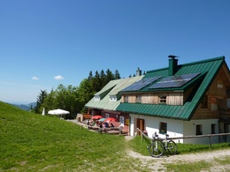
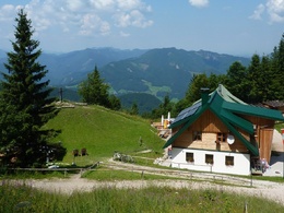
From the Bamacher parking lot, continue on a gravel road always following the road signs Ennserhütte-Almkogel until you reach the so-called Nina hut, a hunting lodge, on the right. Here you keep to the left, after a few meters the hiking trail crosses the road and after about 2 km the road to the Ennserhütte branches off to the right at a sharp angle and after a short time you find yourself at the Ennserhütte, 1293 m above sea level, where the road also ends.
Return on the same route, from the parking lot Bamacher is also to be expected with local traffic.
Translated with www.DeepL.com/Translator (free version)
Directions:
From the Bamacher parking lot, continue on a gravel road always following the road signs Ennserhütte-Almkogel until you reach the so-called Nina hut, a hunting lodge, on the right. Here you keep to the left, after a few meters the hiking trail crosses the road and after about 2 km the road to the Ennserhütte branches off to the right at a sharp angle and after a short time you are at the Ennserhütte, 1293 m high, where the road also ends.Return on the same route, from the Bamacher parking lot you must also reckon with local traffic.
Translated with www.DeepL.com/Translator (free version)
Tip:
Bike & Hike: Be sure to plan a hike from the Ennser Hütte to the Almkogel - about 45 minutes in one direction. You will be rewarded with a magnificent panoramic view of the Kalkalpen National Park, the Gesäuse and the Alpine foothills.
Safety guidelines:
Find out in advance about any road and trail closures along the route!
Equipment:
Sun or rain protection, repair kit for minor bike breakdowns
Additional information:
You can obtain map material at www.steyr-nationalpark.at
Starting point: Großraming
Destination: Ennserhütte
further information:
- culinary interesting
- Possible accommodation
details mountainbike
- Riding technique: medium
Parking
- Parking space: 20
- Suitable for groups
- Suitable for single travelers
- Suitable for friends
- Suitable for couples
- Spring
- Summer
- Autumn
Please get in touch for more information.
Stadtplatz 27
4400 Steyr
Phone +43 7252 53229 - 0
mobile +43 664 4430141
E-Mail ennserhuette@gmail.com
Web www.steyr-nationalpark.at/
Web www.ennser-huette.at
https://www.steyr-nationalpark.at/
http://www.ennser-huette.at
http://www.ennser-huette.at
")
Interactive elevation profile
Create PDF
Tour-Details
Starting place: 4463 Großraming
Destination: 4463 Großraming
duration: 4h 9m
length: 23,4 km
Altitude difference (uphill): 1.015m
Altitude difference (downhill): 1.015m
Lowest point: 375m
Highest point: 1.330m
difficulty: medium
condition: medium
panoramic view: Dreamtour
Paths covering:
Asphalt, Path / trail, Gravel
powered by TOURDATA