

Ski tour Warscheneck - Zeller path (tour area Vorderstoder)


- Possible accommodation
Interactive elevation profile
Create PDF
Tour-Details
Starting place: 4574 Vorderstoder
Destination: 4574 Vorderstoder
duration: 9h 52m
length: 15,1 km
Altitude difference (uphill): 1.762m
Altitude difference (downhill): 1.769m
Lowest point: 734m
Highest point: 2.364m
difficulty: difficult
condition: difficult
panoramic view: Dreamtour
Paths covering:
snow
powered by TOURDATA
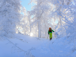
The Warscheneck about the Zeller corridor is a very safe, popular and one of the longest ski tours of the region and it offers a fantastic panoramic view. From the parking lot you must follow the signs ski . First, keep to the left , then over meadows straight up , cross the road and continue to the edge of the forest . Now go to the forest road towards Zellerhütte to the valley station of the ropeway . Now we ever steeper and you get to Zellerhütte to 1.575 m . From the hut we continue on a flatter and brighter larch forest up the mountain on the Schaller Kogel . From here it goes Bergau about free hanging , by poles below. The Lagelsberg you miss, and further by poles in the slight ups and downs over the plateau uphill . In fog or bad weather, you should go in no further , you lose here easy orientation. Finally, you go on beautiful slopes, always the summit cross from Warscheneck in sight , up , until at last the summit is reached.
Departure:
Same as the ascent ,
on the plateau , the descent is often deceptive, because the rocks are usually only covered with a thin layer of snow . From the Zellerhütte it comes in a nice ride just down the corridor Zeller . Due to the north -side location there is often a fantastic powder snow.
Starting point: Parking Rotbuchner Vorderstoder
Destination: Parking Rotbuchner Vorderstoder
further information:
- Possible accommodation
- Board possible
Details - Ski
- Descent: difficulty: difficult, 1650 Metres of altitude
Accessibility / arrival
From Windischgarsten drive towards Hinterstoder / Vorderstoder. After Roßleithen the road goes a hill and you arrive at a 180 ° right turn in the parking is located Rotbuchner.
Most economical season
- Early winter
- Deep winter
Please get in touch for more information.
Vorderstoder 66
4574 Vorderstoder
Phone +43 7564 8255
Fax machine +43 7564 8255 - 20
E-Mail vorderstoder@pyhrn-priel.net
Web www.urlaubsregion-pyhrn-priel.at
http://www.urlaubsregion-pyhrn-priel.at
")
Interactive elevation profile
Create PDF
Tour-Details
Starting place: 4574 Vorderstoder
Destination: 4574 Vorderstoder
duration: 9h 52m
length: 15,1 km
Altitude difference (uphill): 1.762m
Altitude difference (downhill): 1.769m
Lowest point: 734m
Highest point: 2.364m
difficulty: difficult
condition: difficult
panoramic view: Dreamtour
Paths covering:
snow
powered by TOURDATA