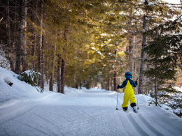
Cross-country skiing "Schilift"
Path number: Markierung: gelb
Starting place: 4251 Sandl
Destination: 4251 Sandl
Not in operation
skating trail
4 km skating trail, slightlyDogs not allowed!
Path number: Markierung: gelb
Starting place: 4251 Sandl
Destination: 4251 Sandl
duration: 0h 27m
length: 1,9 km
Altitude difference (uphill): 30m
difficulty: easy
condition: easy
panoramic view: Great panorama
Paths covering:
snow
Starting point: Viehberghütte / ski lift
Destination: Viehberghütte / ski lift
further information:
- Flatly
- Board possible
Details - Trail
- Nordic skiing facilities: Marked Nordic skiing run
- Type of Nordic skiing run: Classic style
- free
wintertime
Accessibility / arrival
Coming from Linz via the A7 and S10 - exit Grünbach/Sandl - then continue on the B38 towards Sandl.
At the entrance to Sandl (coming from Freistadt) - turn left towards Viehberg (signposted)!
- Parking space: 50
- Bus parking space: 5
General price information
Voluntary donation!
- voluntary contribution
- Suitable for groups
- Suitable for schools
- Suitable for teenagers
- Suitable for seniors
- Suitable for single travelers
- Suitable for families
- Suitable for friends
- Suitable for couples
- Early winter
- Deep winter
Please get in touch for more information.
Sandl 28
4251 Sandl
Phone +43 7944 81006
E-Mail office@gasthof-fleischbauer.at


