Dachstein Schulter via ferrata


- Multi-day tour
Interactive elevation profile
Create PDF
Tour-Details
Paths covering:
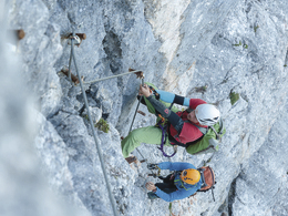
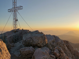
Climb to the highest summit in Upper Austria
This via ferrata is the highlight of a wonderful high-altitude tour that starts from Obertraun and leads over the Simonyhütte to the Dachstein summit.
You start with the Dachstein Krippenstein cable car followed by a hike to the Simonyhütte (approx. 4.5 hours). From there it goes over the glacier to the beginning of the via ferrata. Then in about an hour to the summit of the Dachstein.
Attention: The via ferrata is not difficult, but this is a tour in high alpine terrain and appropriate preparation and alpine knowledge are essential!
Alternative route: Via Ramsau, on the south side of the Dachstein, you can also take the cable car directly to the glacier, from there it is relatively relaxed to the entrance to the via ferrata, a lot of time can be saved here, but not to be underestimated here either.
Experience a 360° panorama tour of the Dachstein Krippenstein…
In case of emergency call the mountain rescue under 140
Download the via ferrata guide of Bad Goisern, Gosau at Dachstein, Hallstatt and Obertraun.
further information:
- Multi-day tour
Details - climbing mount
- difficulty acc. to Kurt Schall: medium difficulty (B)
- duration hop on: 2 h
- duration climbing mount: 1 h
- duration Descent: 2 h
by car
from Salzburg:
Federal road B158 direction Bad Ischl
in Bad Ischl driveway onto Salzkammergut Straße B145 in direction to Bad Goisern, Hallstatt and Obertraun
from Linz:
A1 motorway exit Regau on Salzkammergut Straße B145 direction Gmunden, Bad Goisern, Hallstatt and Obertraun
from Graz:
A9 motorway exit Liezen on B320
in Trautenfels turn onto Salzkammergut Straße B145 via Bad Aussee to Obertraun
from Villach:
A10 Tauernautobahn to exit "Eben im Pongau", from there via Annaberg, Gosau and Hallstatt to Obertraun
by bus:
get off at the bus station “Obertraun Feriendorf”, from there 500 m walk
by train:
from Linz/Salzburg to Attnang-Puchheim, change to train to Stainach-Irdning
or from Stainach-Irdning Zug direction Attnang-Puchheim
get off at train station "Obertraun-Dachsteinhöhlen", from there 1.4 km walk
Detailed information on the respective train and bus times can be found at https://www.oebb.at/en/ (train) and https://www.postbus.at/en(bus).
- Parking space: 200
- Parking area for disabled: 5
- Bus parking space: 12
- Suitable for single travelers
- Suitable for friends
- Suitable for couples
- Spring
- Summer
- Autumn
Please get in touch for more information.
Obertraun
4831 Obertraun
Phone +43 5 95095 - 40
E-Mail obertraun@dachstein-salzkammergut.at
Web www.dachstein-salzkammergut.at
You can also visit us on
Visit us on Facebook Visit us on Instagram Visit us on Pinterest Visit our videochannel on YouTube WikipediaInteractive elevation profile
Create PDF
Tour-Details
Paths covering: