

Climbing area Adlerspitz


Interactive elevation profile
Create PDF
Tour-Details
Starting place: 4853 Steinbach am Attersee
Destination: 4853 Steinbach am Attersee
duration: 2h 2m
length: 2,8 km
Altitude difference (uphill): 516m
Lowest point: 646m
Highest point: 1.162m
difficulty: medium
condition: medium
panoramic view: Some Views
Paths covering:
Climbing mount, Hiking trail
powered by TOURDATA
information: Akutmeldung/Information
Description: ATTENTION, this is NOT an official via ferrata!
All information without guarantee, the use is of course at your own risk.
The next official via ferrata is the Mahdlgupf via ferrata.
Traditional climbing on beautiful trails.
The distinctive Adlerspitz can be reached in about an hour via the marked Trail No. 824 from Gasthaus Kienklause in the direction of the Hochleckenhaus. The Niederer Rast offers a marvellous view of the striking rock towers. This is also where there is a fork in the path, leading to the Adlerspitz just a few minutes away.
Get inspired now and try the 360° perspective tour!
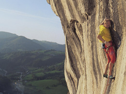
This is the oldest and most well-established climbing area in the Höllengebirge and offers well-protected, rewarding routes at difficulty grade II and above. Despite this, the area is still relatively quiet. Protection is somewhat sparse along the easy routes, while the majority of the more difficult climbs have been refurbished extremely well. One of the most attractive climbs is the Seeturm northwest flank. The tour crosses solid rock via a corner (VI grade of difficulty) up to the Seeturm. Franz Scheckenberger and Hias Aigner were the first to complete this climb in autumn 1938.
The distinctive Adlerspitz can be reached in about an hour via the marked Trail No. 824 from Gasthaus Kienklause in the direction of the Hochleckenhaus. The Niederer Rast offers a marvellous view of the striking rock towers. This is also where there is a fork in the path, leading to the Adlerspitz just a few minutes away.
Get inspired now and try the 360° perspective tour!
This is the oldest and most well-established climbing area in the Höllengebirge and offers well-protected, rewarding routes at difficulty grade II and above. Despite this, the area is still relatively quiet. Protection is somewhat sparse along the easy routes, while the majority of the more difficult climbs have been refurbished extremely well. One of the most attractive climbs is the Seeturm northwest flank. The tour crosses solid rock via a corner (VI grade of difficulty) up to the Seeturm. Franz Scheckenberger and Hias Aigner were the first to complete this climb in autumn 1938.
Details - climbing mount
Parking
- Parking space: 15
- Suitable for single travelers
- Suitable for friends
- Suitable for couples
- Spring
- Summer
- Autumn
Please get in touch for more information.
4853 Steinbach am Attersee
Phone +43 7663 401
E-Mail info.steinbach@attersee.at
Web attersee-attergau.salzkammergut.at
https://attersee-attergau.salzkammergut.at
Interactive elevation profile
Create PDF
Tour-Details
Starting place: 4853 Steinbach am Attersee
Destination: 4853 Steinbach am Attersee
duration: 2h 2m
length: 2,8 km
Altitude difference (uphill): 516m
Lowest point: 646m
Highest point: 1.162m
difficulty: medium
condition: medium
panoramic view: Some Views
Paths covering:
Climbing mount, Hiking trail
powered by TOURDATA