

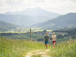
1d Circular hiking trail "Hipping - Hag"


- pets allowed
- Flatly
Interactive elevation profile
Create PDF
Tour-Details
Starting place: 4880 Berg im Attergau
Destination: 4880 Berg im Attergau
duration: 3h 0m
length: 13,0 km
Altitude difference (uphill): 150m
difficulty: medium
condition: medium
panoramic view: Great panorama
Paths covering:
Asphalt, Gravel, Hiking trail
powered by TOURDATA
Hike from Hipping to the Lichtenberg and to the Attergau observation tower.
You start at the parking lot at the Voralpenhotel Schmoller. Follow the road in the direction of Kogl Castle, but turn right before you reach the castle park and continue along the avenue of trees.
Continue along the tree-lined avenue until you reach the road, follow it for about 30 meters to the right and keep left in front of the Spitzerwirt country inn.
Now continue along the road until you reach the rehabilitation center at Kogl and about 20 meters
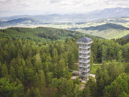
after the rehabilitation center, turn right onto the Lichtenberg. After one has now uphill, you will come to a fork in the road, where you reach the Attergau lookout tower. But here you follow the follow the signs and hike a short distance on the Lichtenberg circular trail.
After about 1 km you come to a crossroads, from where you can reach the from where you can reach the Attergau lookout tower in 10 minutes. At this point you return to Hipping. You follow the the signs to the village of Hag until you reach the federal road Weißenkirchen and cross the road in the direction of Pössing. In Pössing you keep right, before you turn left in front of the Genussbackstube Muss turns left in the direction of Hipping to get back to the starting point. to get back to the starting point.
REFRESHMENT STOPS:
Landgasthof Spitzer, Kogl, day off: Monday
Genussbackstube Muss / Pössing (opening hours: Tue: 14:00-17:00 & Fri: 9:00-12:00)
Voralpenhotel Schmoller, Hipping, day off: Thursday
You start at the parking lot at the Voralpenhotel Schmoller. Follow the road in the direction of Kogl Castle, but turn right before you reach the castle park and continue along the avenue of trees.
Continue along the tree-lined avenue until you reach the road, follow it for about 30 meters to the right and keep left in front of the Spitzerwirt country inn.
Now continue along the road until you reach the rehabilitation center at Kogl and about 20 meters
after the rehabilitation center, turn right onto the Lichtenberg. After one has now uphill, you will come to a fork in the road, where you reach the Attergau lookout tower. But here you follow the follow the signs and hike a short distance on the Lichtenberg circular trail.
After about 1 km you come to a crossroads, from where you can reach the from where you can reach the Attergau lookout tower in 10 minutes. At this point you return to Hipping. You follow the the signs to the village of Hag until you reach the federal road Weißenkirchen and cross the road in the direction of Pössing. In Pössing you keep right, before you turn left in front of the Genussbackstube Muss turns left in the direction of Hipping to get back to the starting point. to get back to the starting point.
REFRESHMENT STOPS:
Landgasthof Spitzer, Kogl, day off: Monday
Genussbackstube Muss / Pössing (opening hours: Tue: 14:00-17:00 & Fri: 9:00-12:00)
Voralpenhotel Schmoller, Hipping, day off: Thursday
Starting point: Voralpenhotel Schmoller
Destination: Voralpenhotel Schmoller
further information:
- Flatly
- Board possible

Accessibility / arrival
By car:
From Salzburg via motorway A1 – Exit St. Georgen im Attergau – right on the Attergaustraße (L540) to the center.
From Vienna/Linz via motorway A1 – Exit St. Georgen im Attergau – right on the Attergaustraße (L540) to the center.
From Bad Ischl – Weißenbachtal (B153) – follow B152 to Unterach and then B151 to Attersee than left to the Attergaustraße (L540) to St. Georgen.
By train:
From Salzburg or Linz/Vienna with „Austrian Federal Railways“ or „Westbahn“ to Attnang Puchheim - via regional train to Vöcklamarkt and St. Georgen
By plane:
Arrival to Airport Salzburg or Linz – with the car/bus or train to St. Georgen im Attergau.
- Pets allowed
- Suitable for seniors
- Suitable for single travelers
- Suitable for friends
- Suitable for couples
- Suitable for children
- Spring
- Summer
- Autumn
Please get in touch for more information.
Attergaustraße 55
4880 St. Georgen im Attergau
Phone +43 7666 7719 - 80
E-Mail info.attergau@attersee.at
Web attersee-attergau.salzkammergut.at
https://attersee-attergau.salzkammergut.at
You can also visit us on
Visit us on Facebook Visit us on Instagram Visit us on Pinterest Visit our videochannel on YouTube Wikipedia")
")
")
")
Interactive elevation profile
Create PDF
Tour-Details
Starting place: 4880 Berg im Attergau
Destination: 4880 Berg im Attergau
duration: 3h 0m
length: 13,0 km
Altitude difference (uphill): 150m
difficulty: medium
condition: medium
panoramic view: Great panorama
Paths covering:
Asphalt, Gravel, Hiking trail
powered by TOURDATA