

Singletrail Wurzeralm


- All weather
- Suitable for families
Interactive elevation profile
Create PDF
Tour-Details
Starting place: 4582 Spital am Pyhrn
Destination: 4582 Spital am Pyhrn
duration: 0h 12m
length: 5,0 km
Altitude difference (uphill): 41m
Altitude difference (downhill): 637m
Lowest point: 821m
Highest point: 1.420m
difficulty: medium
condition: medium
panoramic view: Great panorama
Paths covering:
Path / trail, Other
powered by TOURDATA
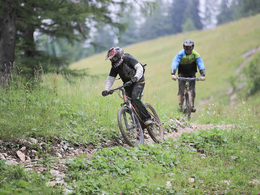
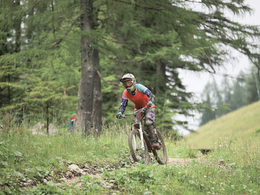
The 4.5-kilometer single trail on the Wurzeralm leads from over 1,400 meters above sea level through moderately difficult terrain (difficulty level red) down to the valley station of the funicular.
On the way down, the route crosses over 600 heights, the slope being quite even and never very steep. The trail is therefore also suitable for less experienced bikers and families. The trail "Blue Lollipop" at the Bikepark Wurbauerkogel is quite similar to the singletrail Wurzeralm by the way.
The course was worked out together with landowners, nature conservation and the Federal Forests. Alpreif, a specialist in the field of regional infrastructure development, was entrusted with the construction supervision. The singletrail ends at the valley station Wurzeralm, where a laundry box for bicycle cleaning is available.
We kindly ask you to take into account that the driving of the forest roads is unfortunately not allowed.
Starting point: Bergstation Wurzeralm cable car
Destination: Valley station Wurzeralm cable car
details mountainbike
- Riding technique: medium
- Ascent aid available
Only at the operating times of the Wurzeralm cable car
Accessibility / arrival
Private:
From Windischgarsten on the B138 direction Liezen (Styria) before the Pyhrnpass, on the right hand side, or via the A9 Pyhrn-Autobahn to exit Spital am Pyhrn - B138 direction Liezen
Public:
With the ÖBB-Postbus (line 911) to stop Wurzeralmseilbahn valley station.
- Parking space: 1000
- Bus parking space: 100
General price information
The same applies to the use of the Wurzeralm cable car as for the Bikepark Wurbauerkogel. All tickets are valid for the Bikepark Wurbauerkogel and for the gondola lift in Hinterstoder.
You want to ride the entire Pyhrn Priel Trailogie in one day? A special trailogie ticket allows one trip per location (Wurzeralm, Hinterstoder, Wurbauerkogel).
Payment methods
Debit and credit cards
ATM card
Mastercard
Visa
Other payment methods
Cash payment
- All weather
- Suitable for groups
- Suitable for teenagers
- Suitable for single travelers
- Suitable for friends
- Suitable for couples
- Spring
- Summer
- Autumn
Please get in touch for more information.
")
Wurzeralm 1
4582 Spital am Pyhrn
Phone +43 3687 24100
E-Mail info@alpreif.at
Web www.alpreif.at
http://www.alpreif.at
")

")

")
Interactive elevation profile
Create PDF
Tour-Details
Starting place: 4582 Spital am Pyhrn
Destination: 4582 Spital am Pyhrn
duration: 0h 12m
length: 5,0 km
Altitude difference (uphill): 41m
Altitude difference (downhill): 637m
Lowest point: 821m
Highest point: 1.420m
difficulty: medium
condition: medium
panoramic view: Great panorama
Paths covering:
Path / trail, Other
powered by TOURDATA