

Salzkammergut cycling path to Ebensee


- pets allowed
Interactive elevation profile
Create PDF
Tour-Details
Starting place: 4801 Traunkirchen
Destination: 4802 Ebensee
duration: 0h 26m
length: 4,5 km
Altitude difference (uphill): 152m
Altitude difference (downhill): 148m
Lowest point: 424m
Highest point: 484m
difficulty: easy
condition: easy
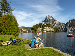
panoramic view: Great panorama
Paths covering:
Asphalt
powered by TOURDATA
Salzkammergut cycling path to Ebensee
Length: 4 km From Traunkirchen Ort - 1 km on the main road in southern direction - to the left in front of the first tunnel onto the cycling path - along the old main road (Bundesstraße) - Lion´s Monument - Ebensee
Possible connections/ combinations:
Ebensee - Langbathseen - Ebensee (+ 24 km)
Salzkammergut cycling path to Bad Ischl (+ 17 km)
Salzkammergut cycling path to the holiday regions of: Lake Attersee, Inner Salzkammergut and Lake Wolfgangsee
- Pets allowed
- Spring
- Summer
- Autumn
Please get in touch for more information.
4813 Altmünster
Phone +43 7612 74451
E-Mail info@traunsee-almtal.at
Web www.traunsee-almtal.at
http://www.traunsee-almtal.at
Interactive elevation profile
Create PDF
Tour-Details
Starting place: 4801 Traunkirchen
Destination: 4802 Ebensee
duration: 0h 26m
length: 4,5 km
Altitude difference (uphill): 152m
Altitude difference (downhill): 148m
Lowest point: 424m
Highest point: 484m
difficulty: easy
condition: easy
panoramic view: Great panorama
Paths covering:
Asphalt
powered by TOURDATA