

Motion Arena Fraitgraben course - red W3


- Flatly
Interactive elevation profile
Create PDF
Tour-Details
Starting place: 4580 Edlbach
Destination: 4580 Edlbach
duration: 2h 13m
length: 7,3 km
Altitude difference (uphill): 214m
Altitude difference (downhill): 213m
Lowest point: 638m
Highest point: 791m
difficulty: difficult
condition: difficult
panoramic view: Great panorama
Paths covering:
Asphalt, Gravel
powered by TOURDATA
Motion Arena Windischgarsten-Spital am Pyhrn - Fraitgraben course - red W3
The red Fraitgraben course takes you through an enchanting natural setting. Gently, yet constantly uphill, the path takes you through the Fraitgraben. As you climb, you will be treated to unbelievable views of the surrounding Totes Gebirge mountains. Now on a changing surface, the last stretch takes you downhill and back to the info board by the lake.
The route can be shortened at km 1.6, length of route: 3.90 km
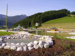
Starting point: Swimming Lake Edlbach
Destination: Swimming Lake Edlbach
further information:
- Flatly
- Board possible
Accessibility / arrival
Golfsalettl the golf course Windischgarsten Pyhrn-Priel
Most economical season
- Spring
- Summer
- Autumn
Please get in touch for more information.

Bahnhofstraße 2
4580 Windischgarsten
Phone +43 7562 5266
Fax machine +43 7562 5266 - 10
E-Mail info@pyhrn-priel.net
Web www.urlaubsregion-pyhrn-priel.at
http://www.urlaubsregion-pyhrn-priel.at
")
")
")
Interactive elevation profile
Create PDF
Tour-Details
Starting place: 4580 Edlbach
Destination: 4580 Edlbach
duration: 2h 13m
length: 7,3 km
Altitude difference (uphill): 214m
Altitude difference (downhill): 213m
Lowest point: 638m
Highest point: 791m
difficulty: difficult
condition: difficult
panoramic view: Great panorama
Paths covering:
Asphalt, Gravel
powered by TOURDATA