

From St. Lorenz to the Almkogel


- Suitable for families
Interactive elevation profile
Create PDF
Tour-Details
Starting place: 5310 St. Lorenz am Mondsee
Destination: 5310 St. Lorenz am Mondsee
duration: 3h 0m
length: 3,9 km
Altitude difference (uphill): 481m
Altitude difference (downhill): 476m
Lowest point: 492m
Highest point: 930m
difficulty: medium
condition: medium
panoramic view: Great panorama
Paths covering:
Path / trail, Street, Other
powered by TOURDATA
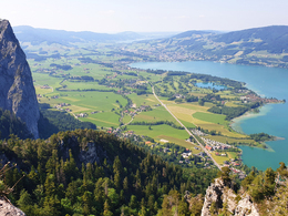
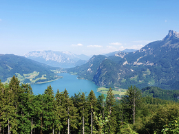
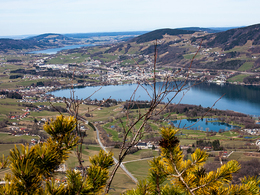
Beautiful panoramic tour to the lookout mountain Almkogel in the municipality of St. Lorenz/Mondsee.
We start this hike at the parking lot of the Drachenwand via ferrata. We pass the Gasthof Drachenwand, shortly thereafter we turn right towards Almkogel (Path no. 12). From there into the forest until we reach the so called "Thekla"-chapel. After crossing the Klausenbach we keep left. From here a steep ascent through the forest begins, which is rewarded at the summit of the Almkogel with a fantastic view over the region of Mondsee and Irrsee.
On the descent we take the same route as the ascent.
- Suitable for single travelers
- Suitable for friends
- Suitable for couples
- Spring
- Summer
- Autumn
Please get in touch for more information.
Dr. Franz Müller Straße 3
5310 St. Lorenz am Mondsee
Phone +43 6232 2270
Fax machine +43 6232 2270 - 22
E-Mail info@mondsee.at
Web www.mondsee.at
http://www.mondsee.at
Interactive elevation profile
Create PDF
Tour-Details
Starting place: 5310 St. Lorenz am Mondsee
Destination: 5310 St. Lorenz am Mondsee
duration: 3h 0m
length: 3,9 km
Altitude difference (uphill): 481m
Altitude difference (downhill): 476m
Lowest point: 492m
Highest point: 930m
difficulty: medium
condition: medium
panoramic view: Great panorama
Paths covering:
Path / trail, Street, Other
powered by TOURDATA