

Bohemian dream


- Flatly
- Possible accommodation
Interactive elevation profile
Create PDF
Tour-Details
Starting place: 4170 St. Stefan-Afiesl
Destination: 4170 St. Stefan-Afiesl
duration: 5h 0m
length: 69,0 km
Altitude difference (uphill): 810m
Altitude difference (downhill): 810m
Lowest point: 725m
Highest point: 1.034m
difficulty: difficult
condition: difficult
panoramic view: Some Views
Paths covering:
Asphalt, Gravel
powered by TOURDATA
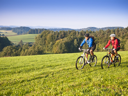
The bike and mountain bike route "Bohemian Dream" is demanding - but fantastic - because everything from romantic forest routes, relaxing sea routes to breathtaking viewpoints is included.
The Bohemian Dream takes you across the Bohemian Forest, a little way along the 'Schwarzenberger Schwemmkananals', up to the 'Alpenblick' viewing platform and on to the beautiful lake and bank landscape of the Vltava River. In addition, this route connects four of the 7 TOP.HOTELS Mühlviertel.
Starting point: several entry points at the Mühlviertler Hochland: Hotel AVIVA, Hotel Bergergut, Hotel Guglwald
Destination: The target point corresponds to the respective starting point in the Mühlviertler Hochland: Hotel AVIVA, Hotel Bergergut, Hotel Guglwald
further information:
- Flatly
- Possible accommodation
- Board possible
details mountainbike
- Riding technique: medium
Open every day - not accessible when there is snow.
Accessibility / arrival
coming from LINZ: B126 to “Bad Leonfelden” - further in the direction of “Rohrbach” on the B38 - turn right after “Vorderweißenbach” onto the L1544 (the TraumArena is well-marked) - after 8 km (Hotel Bergergut), you will arrive at one of the entry points.
Coming from PASSAU: on the B338 towards Austria / “Rohrbach” - (turns into the B38 on the Austrian side) - further on in the direction of “Freistadt” - turn left after “Haslach a.d. Mühl” onto the L1544 towards “St. Stefan a. Walde” (the TraumArena is well marked) - after 7 km (Hotel Bergergut), you will arrive at one of the entry points.
- Parking space: 35
- Suitable for groups
- Suitable for schools
- Suitable for single travelers
- Suitable for friends
- Suitable for couples
- Spring
- Summer
- Autumn
Please get in touch for more information.
Hauptplatz 19
4190 Bad Leonfelden
Phone +43 7213 6397
Fax machine +43 7213 6397 - 13
E-Mail office@muehlviertlerhochland.at
Web www.muehlviertlerhochland.at
https://www.muehlviertlerhochland.at
Interactive elevation profile
Create PDF
Tour-Details
Starting place: 4170 St. Stefan-Afiesl
Destination: 4170 St. Stefan-Afiesl
duration: 5h 0m
length: 69,0 km
Altitude difference (uphill): 810m
Altitude difference (downhill): 810m
Lowest point: 725m
Highest point: 1.034m
difficulty: difficult
condition: difficult
panoramic view: Some Views
Paths covering:
Asphalt, Gravel
powered by TOURDATA