

Zäpfensteig circular route


- Flatly
Interactive elevation profile
Create PDF
Tour-Details
Path number: 13
Starting place: 5350 Strobl
Destination: 5350 Strobl
duration: 2h 0m
length: 7,7 km
Altitude difference (uphill): 61m
Altitude difference (downhill): 68m
Lowest point: 538m
Highest point: 601m
difficulty: medium
condition: medium
panoramic view: Some Views
Paths covering:
Asphalt, Gravel
powered by TOURDATA
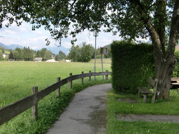
A medium ability run with views to the surrounding landscape. From the Strobl bus station (parking available) take the footpath eastwards away from Strobl, (Vocknerweg path) under the Wolfgang road to the Gasthaus Weissenbach (guesthouse). From here, go right, past the Hotel Bergrose to Gasthaus Weberhäusl (guesthouse) and right again to the bend in the road. Go left, here and immediately right onto the Zäpfensteig (path) via the Urschlag (hamlet) to the Gasthaus Mahdhäusl (guesthouse). Right, downhill and before the main road, go right over the walkway, then under the road to the Lipphaus (local history museum) and left to the railway embankment path. Then go right via the sports ground and straight on eastwards back to the starting point.
Distance: 8 km
Elevation difference: 100 m
Gravel-Course: 4 km
Tarmac-Course: 4 km
Time: 27 to 54 min
Nordic Walking: 96 min
Distance: 8 km
Elevation difference: 100 m
Gravel-Course: 4 km
Tarmac-Course: 4 km
Time: 27 to 54 min
Nordic Walking: 96 min
Starting point: Bus station Strobl
Destination: Bus station Strobl
further information:
- Flatly
Accessibility / arrival
Leave the main road in Strobl east,
then to Bahnstreet.
You can find a lot of parking.
- Parking space: 50
- Suitable for single travelers
- Suitable for friends
- Suitable for couples
- Spring
- Summer
- Autumn
Please get in touch for more information.
Moosgasse 275
5350 Strobl
Phone +43 6137 7255
Fax machine +43 6137 5958
E-Mail office@wolfgangsee.at
Web www.wolfgangsee.at
http://www.wolfgangsee.at
Interactive elevation profile
Create PDF
Tour-Details
Path number: 13
Starting place: 5350 Strobl
Destination: 5350 Strobl
duration: 2h 0m
length: 7,7 km
Altitude difference (uphill): 61m
Altitude difference (downhill): 68m
Lowest point: 538m
Highest point: 601m
difficulty: medium
condition: medium
panoramic view: Some Views
Paths covering:
Asphalt, Gravel
powered by TOURDATA