

Bad Haller Steig via the Gowilalm to the Great Pyhrgas 2,244m
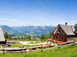


- culinary interesting
- Possible accommodation
Interactive elevation profile
Create PDF
Tour-Details
Path number: 616
Starting place: 4582 Spital am Pyhrn
Destination: 4582 Spital am Pyhrn
duration: 3h 0m
length: 5,8 km
Altitude difference (uphill): 1.376m
Altitude difference (downhill): 26m
Lowest point: 868m
Highest point: 2.218m
difficulty: medium
condition: difficult
panoramic view: Great panorama
Paths covering:
Climbing mount, Gravel, Hiking trail
powered by TOURDATA
This mountain tour with easy climbing sections leads you via the Gowilalm and over the Bad-Haller-Steig to the summit of the Great Pyhrgas.
The trail requires surefootedness and a head for heights!
Caution: There is a danger of falling rocks in places! - Especially if there are several groups on the trail!
Starting point for Gowilalm is Flinderlmühle in Oberweng near Spital am Pyhrn, parking spots are found between Jausenstube Singerskogel and Goslitzbauer in Oberweng. From here trail no. 616 leads steadily upwards on a forest path, mostly through shady alpine forests to Gowilalm.
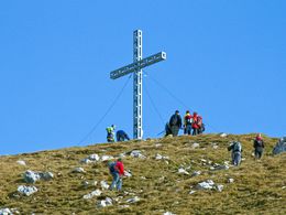
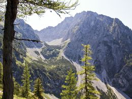
At Gowilalm proceed upwards to the east (note signpost!) to the southern edge of the pasture. Through larch forest, the trail leads slightly descending past a water source and crosses the western flank of the Kleiner Pyhrgas up to a ridge with mountain pines. It is crossed above a channel drop off (fixed rope - be aware of falling rocks). Transverse downward to get to the base of the rock crashes (memorial cross for Franz Gössweiner) and the rubble filled corrie basin of Holzerkar between Kleiner and Großer Pyhrgas. The marker is followed by a scree up to the foot of the Northeast crashes. Here is the entrance (big red markings) where you cross to the right and follow the fixed rope. There is a steep grassy slope with grass rock outcrops (rockfall hazard if several mountaineers are climbing). In places, the trail leads along fixed ropes to the northeast ridge. Follow the safety ropes partially zigzagging upwards to the cross decorated summit. The best time for this demanding tour is - depending on the weather - between June and the end of September.
Großer Pyhrgas is with its 2,244 metres the highest point of the Haller Mauern and offers a magnificent panorama. To the east lie Scheiblingstein, Hexenturm, to the left the Wiener Hausberge, Oetscher, Ybbstaler Alps, right of the Hexenturm are the Gesäuseberge, Hochschwabmassiv, parts of Eisenerzer Alps, Hochtor- and Reichenstein group, including the basin of Admont. South-east in the distance are the Seckauer- and Triebener Tauern, Zirbitzkogel, from south to southwest Wölzer- and Schladming Tauern, Ankogel group, Grimming, Glockner Group and Dachstein. West of Spital am Pyhrn lies the Warscheneckstock, northwest the wide valley of Windischgarsten, the Krems wall and the Sengsengebirge. From north to northeast the view stretches over the wooded Reichraminger background mountains and foothills of the Alps to the upper Mühlen- and Waldviertel towards Czech Republic.
For the descent (not included in the hiking time) walk a little to the west (signpost!). Left, this means south, along the fixed ropes walk down staged rocky terrain, carefully crossing debris and lawn edges. Finally the path leads through a forest with pines and spruce trees down to Rohrauerhaus.
The trail requires surefootedness and a head for heights!
Caution: There is a danger of falling rocks in places! - Especially if there are several groups on the trail!
Starting point for Gowilalm is Flinderlmühle in Oberweng near Spital am Pyhrn, parking spots are found between Jausenstube Singerskogel and Goslitzbauer in Oberweng. From here trail no. 616 leads steadily upwards on a forest path, mostly through shady alpine forests to Gowilalm.
At Gowilalm proceed upwards to the east (note signpost!) to the southern edge of the pasture. Through larch forest, the trail leads slightly descending past a water source and crosses the western flank of the Kleiner Pyhrgas up to a ridge with mountain pines. It is crossed above a channel drop off (fixed rope - be aware of falling rocks). Transverse downward to get to the base of the rock crashes (memorial cross for Franz Gössweiner) and the rubble filled corrie basin of Holzerkar between Kleiner and Großer Pyhrgas. The marker is followed by a scree up to the foot of the Northeast crashes. Here is the entrance (big red markings) where you cross to the right and follow the fixed rope. There is a steep grassy slope with grass rock outcrops (rockfall hazard if several mountaineers are climbing). In places, the trail leads along fixed ropes to the northeast ridge. Follow the safety ropes partially zigzagging upwards to the cross decorated summit. The best time for this demanding tour is - depending on the weather - between June and the end of September.
Großer Pyhrgas is with its 2,244 metres the highest point of the Haller Mauern and offers a magnificent panorama. To the east lie Scheiblingstein, Hexenturm, to the left the Wiener Hausberge, Oetscher, Ybbstaler Alps, right of the Hexenturm are the Gesäuseberge, Hochschwabmassiv, parts of Eisenerzer Alps, Hochtor- and Reichenstein group, including the basin of Admont. South-east in the distance are the Seckauer- and Triebener Tauern, Zirbitzkogel, from south to southwest Wölzer- and Schladming Tauern, Ankogel group, Grimming, Glockner Group and Dachstein. West of Spital am Pyhrn lies the Warscheneckstock, northwest the wide valley of Windischgarsten, the Krems wall and the Sengsengebirge. From north to northeast the view stretches over the wooded Reichraminger background mountains and foothills of the Alps to the upper Mühlen- and Waldviertel towards Czech Republic.
For the descent (not included in the hiking time) walk a little to the west (signpost!). Left, this means south, along the fixed ropes walk down staged rocky terrain, carefully crossing debris and lawn edges. Finally the path leads through a forest with pines and spruce trees down to Rohrauerhaus.
Starting point: Parking near the Singerskogel mountain inn in Oberweng (47.686856, 14.375854)
Destination: Summit of the great Pyhrgas (47.650374, 14.385350)
further information:
- culinary interesting
- Possible accommodation
- Board possible
June to September depending on snow and weather conditions
")
Accessibility / arrival
The starting point is the parking at the Jausenstube Singerskogel in Oberweng (47.686856, 14.375854)
Most economical season
- Summer
- Autumn
Please get in touch for more information.

Stiftsplatz 1
4582 Spital am Pyhrn
Phone +43 7563 249
E-Mail spital@pyhrn-priel.net
Web www.urlaubsregion-pyhrn-priel.at
http://www.urlaubsregion-pyhrn-priel.at
You can also visit us on
Visit us on Facebook Visit us on Instagram Visit us on Pinterest Visit our videochannel on YouTubeInteractive elevation profile
Create PDF
Tour-Details
Path number: 616
Starting place: 4582 Spital am Pyhrn
Destination: 4582 Spital am Pyhrn
duration: 3h 0m
length: 5,8 km
Altitude difference (uphill): 1.376m
Altitude difference (downhill): 26m
Lowest point: 868m
Highest point: 2.218m
difficulty: medium
condition: difficult
panoramic view: Great panorama
Paths covering:
Climbing mount, Gravel, Hiking trail
powered by TOURDATA