

Hanslalm


- culturally interesting
Interactive elevation profile
Create PDF
Tour-Details
Starting place: 4580 Rosenau am Hengstpaß
Destination: 4580 Rosenau am Hengstpaß
duration: 3h 52m
length: 9,4 km
Altitude difference (uphill): 692m
Altitude difference (downhill): 359m
Lowest point: 861m
Highest point: 1.253m
difficulty: medium
condition: medium
panoramic view: Dreamtour
Paths covering:
Asphalt, Gravel, Hiking trail
powered by TOURDATA
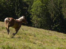
This tour takes us through hilly countryside from Windischgarsten to Hengstpass. You will be able to enjoy marvelous views across
Garstnertal and Kalkalpen National Park! From our starting point at “Reiterhof Schober”, we make our way uphill to the left on a paved road, and after 90 metres we turn left in the direction of “Muttling”. At Sveltinkapelle chapel, our path now takes us left again towards the Haslersgatter. After 500m we come to the start of a gravel road, which soon becomes very steep. Once at the Haslersgatter saddle, the path branches off to the right and continues uphill. After about 400 m, it becomes flatter, continuing up- and downhill for about 3.5 km through the forested hillsides of the Augustinkogel and above the Groiß’n Wiese, then keeping right in the direction of Hengstpass, through rocky narrows and again downhill. After about 800 meters, we meet up with an old forestry road which we follow uphill to the Hanslalm. Once at our destination, we have beautiful views of Garstnertal valley. You can look forward to a culinary treat courtesy of your hosts at the Hanslalm, who also perform under the name “Rainer-Zwoag‘sang”!
The Hanslalm is not far from the trail up to the Wasserklotz, a scenic mountain in the southern Hintergebirge mountains with views of 54 “2,000ers” (difficulty rating: red!).
Return via the same route back to the original starting point.
Starting point: Reiterhof Schober (Wurbauerkogel)
Destination: Reiterhof Schober (Wurbauerkogel)
further information:
- Board possible
Details riding
- Area: easy
- Good riding experience: easy
- Feeding possible for horses
- horse trough
- paddock
Accessibility / arrival
by car:
on the highway Regensburg-Passau A3, exit Bogen (2 km after the services Bavarian Forest) on Hunderdorf, Steinburg just 7 km from Neukirchen - Horseback Schober
General price information
- Daily sticker € 5,00 per day - Buy online here!
- Annual badge € 35.00 per year - Buy online here!
Most economical season
- Summer
Please get in touch for more information.
Bahnhofstraße 2
4580 Windischgarsten
Phone +43 7562 5266
Fax machine +43 7562 5266 - 10
E-Mail info@pyhrn-priel.at
Web www.urlaubsregion-pyhrn-priel.at
https://www.urlaubsregion-pyhrn-priel.at
Interactive elevation profile
Create PDF
Tour-Details
Starting place: 4580 Rosenau am Hengstpaß
Destination: 4580 Rosenau am Hengstpaß
duration: 3h 52m
length: 9,4 km
Altitude difference (uphill): 692m
Altitude difference (downhill): 359m
Lowest point: 861m
Highest point: 1.253m
difficulty: medium
condition: medium
panoramic view: Dreamtour
Paths covering:
Asphalt, Gravel, Hiking trail
powered by TOURDATA