

Bannholzmauer


Interactive elevation profile
Create PDF
Tour-Details
Path number: 5, 8
Starting place: 4581 Rosenau am Hengstpaß
Destination: 4581 Rosenau am Hengstpaß
duration: 0h 57m
length: 2,9 km
Altitude difference (uphill): 118m
Altitude difference (downhill): 114m
Lowest point: 719m
Highest point: 840m
difficulty: easy
condition: easy
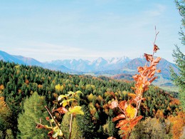
panoramic view: Some Views
Paths covering:
Asphalt, Gravel, Hiking trail
powered by TOURDATA
Hike from the Wurbauerkogel to the Bannholz wall and back to the starting point.
Follow hiking trail no. 5 downhill. At the hiking trail junction, turn right onto hiking trail no. 8 to the Bannholzmauer. Pass the Bannholz wall and take this hiking trail back up to the Wurbauerkogel, to the Bannholzmauer via ferrata park car park. From here you walk another 600m to the starting point at the Wurbauerkogel mountain station.
Hiking trails: 5, 8
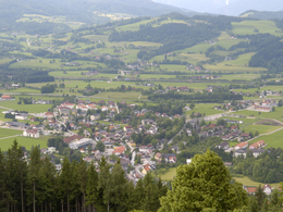
Starting point: The starting point is the mountain station at Wurbauerkogel, which you can reach by chairlift or car. (47.726206, 14.340467)
Destination: Wurbauerkogel mountain station
further information:
- Board possible
April till October
Accessibility / arrival
By foot:
Opposite the Windischgarsten town hall, turn into Kühbergstraße. Cross the Dambach stream and after 200 metres you will reach the valley station of the Wurbauerkogel chairlift.
You can either take the chairlift to the Wurbauerkogel or follow the hiking trail that takes you uphill to the right of the valley station for about 1 hour.
By car:
Drive from the centre of Windischgarsten in the direction of Rosenau. After approx. 2 km, after the Schafflmühle, turn left. At the top, keep left and you will arrive directly at the Klettersteigpark Bannholzmauer car park. (47.726435, 14.347618) It is 600 m to the mountain station.
Most economical season
- Summer
- Autumn
Please get in touch for more information.

Bahnhofstraße 2
4580 Windischgarsten
Phone +43 7562 5266
E-Mail info@pyhrn-priel.net
Web www.pyhrn-priel.net
http://www.pyhrn-priel.net
Interactive elevation profile
Create PDF
Tour-Details
Path number: 5, 8
Starting place: 4581 Rosenau am Hengstpaß
Destination: 4581 Rosenau am Hengstpaß
duration: 0h 57m
length: 2,9 km
Altitude difference (uphill): 118m
Altitude difference (downhill): 114m
Lowest point: 719m
Highest point: 840m
difficulty: easy
condition: easy
panoramic view: Some Views
Paths covering:
Asphalt, Gravel, Hiking trail
powered by TOURDATA