

Rohrauerhaus Mountain biking trail MTB9


- Suitable for families
- Possible accommodation
Interactive elevation profile
Create PDF
Tour-Details
Path number: MTB 9
Starting place: 4582 Spital am Pyhrn
Destination: 4582 Spital am Pyhrn
duration: 2h 57m
length: 19,8 km
Altitude difference (uphill): 1.000m
Altitude difference (downhill): 1.000m
Lowest point: 641m
Highest point: 1.312m
difficulty: medium
condition: medium
panoramic view: Great panorama
Paths covering:
Asphalt, Gravel, Hiking trail, Other
powered by TOURDATA
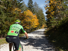
By mountain bike via part of the Spitaler Panoramatour to the Rohrauerhaus.
Short but crisp mountain bike tour with a small single trail (category red).
The mountain bike tour starts at the indoor swimming pool car park in Spital am Pyhrn and first leads to the Jugendparadies Lindenhof. After the fork, turn left and then left again immediately after the railway subway. Now follow the road, which then turns right into a gravel road before you come back to tarmac above and have to turn left.
Now follow the road which leads past the Pantl spring, where the Spital drinking water supply originates and then through the barrier and immediately left up to the house. Behind the house, turn right up the road and follow the path to the left at the next junction.
After a short downhill section, turn left and follow the road to the power station. From here, the trail leads downhill on a forest path and, keeping left, you come to the Bosruck goods road (ATTENTION: for inexperienced cyclists, this single trail in the red category is a HIKING DISTANCE!).
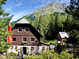
Now ride up the goods road on the left, always following it to the Bosruckhütte. After passing the hut, continue uphill along the road to the Rohrauerhaus. Return either along the same route or via the goods road back to the starting point.
Short but crisp mountain bike tour with a small single trail (category red).
The mountain bike tour starts at the indoor swimming pool car park in Spital am Pyhrn and first leads to the Jugendparadies Lindenhof. After the fork, turn left and then left again immediately after the railway subway. Now follow the road, which then turns right into a gravel road before you come back to tarmac above and have to turn left.
Now follow the road which leads past the Pantl spring, where the Spital drinking water supply originates and then through the barrier and immediately left up to the house. Behind the house, turn right up the road and follow the path to the left at the next junction.
After a short downhill section, turn left and follow the road to the power station. From here, the trail leads downhill on a forest path and, keeping left, you come to the Bosruck goods road (ATTENTION: for inexperienced cyclists, this single trail in the red category is a HIKING DISTANCE!).
Now ride up the goods road on the left, always following it to the Bosruckhütte. After passing the hut, continue uphill along the road to the Rohrauerhaus. Return either along the same route or via the goods road back to the starting point.
Starting point: Parking lot at the indoor swimming pool in Spital am Pyhrn
Destination: Rohrauerhaus
further information:
- Possible accommodation
- Board possible
details mountainbike
- Riding technique: medium
Cycling and mountain biking is allowed from April 15th to October 31st 2 hours after sunrise to 1 hour before sunset and is only allowed on marked routes. Some bike paths are also designated as hiking trails or riding trails. Always count on oncoming hikers or riders!

Accessibility / arrival
From the Spital am Pyhrn motorway exit (A9), turn left into Spital am Pyhrn. The start and end point is at the parking lot of the indoor swimming pool.
- Suitable for groups
- Suitable for schools
- Suitable for teenagers
- Suitable for single travelers
- Suitable for friends
- Suitable for couples
- Spring
- Summer
- Autumn
Please get in touch for more information.

Stiftsplatz 1
4582 Spital am Pyhrn
Phone +43 7563 249
Fax machine +43 7563 249 - 20
E-Mail spital@pyhrn-priel.net
Web www.urlaubsregion-pyhrn-priel.at
http://www.urlaubsregion-pyhrn-priel.at
")
")
")
Interactive elevation profile
Create PDF
Tour-Details
Path number: MTB 9
Starting place: 4582 Spital am Pyhrn
Destination: 4582 Spital am Pyhrn
duration: 2h 57m
length: 19,8 km
Altitude difference (uphill): 1.000m
Altitude difference (downhill): 1.000m
Lowest point: 641m
Highest point: 1.312m
difficulty: medium
condition: medium
panoramic view: Great panorama
Paths covering:
Asphalt, Gravel, Hiking trail, Other
powered by TOURDATA