

4. Etappe - Braunau am Inn bis St. Wolfgang


- All weather
- Suitable for families
- culinary interesting
- culturally interesting
- Possible accommodation
Interactive elevation profile
Create PDF
Tour-Details
Starting place: 5280 Braunau am Inn
Destination: 5360 St. Wolfgang im Salzkammergut
duration: 6h 18m
length: 95,6 km
Altitude difference (uphill): 884m
Altitude difference (downhill): 683m
Lowest point: 347m
Highest point: 810m
difficulty: easy
condition: easy
panoramic view: Dreamtour
Paths covering:
Asphalt
powered by TOURDATA
This is the queen stage of the whole tour, the landscape becomes more and more impressive the closer you get to the mountains. At the end, you cycle along three beautiful Salzkammergut lakes. The Mattigtal cycle path picks us up in Braunau. The easiest way to find it is to cycle back down to the Inn and downstream to the signposted junction. Alternatively, from Salzburger Straße, the continuation of the town square, turn left into Färbergasse and then continue straight along the Haselbacher footpath until you find the signposts for the Mattigtal cycle path. You will pass the church of St Valentin in Haselbach, which is well worth seeing and an unjustly unknown gem. Gradually you leave the town and enter the rural landscape of the lower Mattigtal valley.
A cultural stop would be the church of St. Georgen an der Mattig with its baroque altars by the Zürn brothers, but unfortunately it is closed and to visit it you have to register at the parish office two days in advance (!). You pass the stately market town of Mauerkirchen and soon catch sight of the tower of St Florian near Helpfau. This church - situated on a hill - is also closed, but together with the fish ponds in front of it, it offers a picturesque photo motif.
The cycle path turns right, crosses the Mattigtal valley and comes to the market town of Uttendorf with a large square and several churches. The route continues on the other side of the valley. The cycle path does not touch the town of Mattighofen, but heads towards Pfaffstätt, where we leave it, turn left into the town and turn right into the road labelled "Munderfing".
Munderfing is a typical Innviertel village, which you drive through until you reach the Landgasthaus Graf, opposite which there is a bridge over the Schwemmbach on the right. Turn left at the next road, but then continue straight on along the Roman road where the road bends to the right at a small chapel. This brings you to the village of Valentinhaft with its church, where a hole in the wall to the right of the entrance marks the spot where St Wolfgang reached through the wall to unlock the church from the inside. Cycle on below the church, turn left in Oberhaft and then right at the railway track. At the "Teichstätt" railway stop, visit the castle that has been transformed into a farm, where St. Wolfgang is known to have stayed. He drew up a document there. Back to the Ledl inn, cross the railway and immediately turn left onto the road that leads to Lengau.
After visiting the "giant grave" at the cemetery next to the church gate, continue in the same direction on the "Barocktour" cycle path to Roidwalchen, which is already in the province of Salzburg and where you turn left into the next larger town, Straßwalchen. Before you get there, you pass a huge car storage centre, where there are separate sectors for each type and make of car.
In Straßwalchen you end up on the market square. Head south towards Salzburg and after a short distance turn into the road leading to Mondsee. A cycle path starts again on the right-hand side, which takes you through the interesting villages of Irrsdorf and Oberhofen, and you are back in Upper Austria. Soon afterwards you can see the Zellersee or Irrsee lake, down into the hollow of which you descend in a lively ride. The route on the western shore is also more recommendable for cyclists as it is far more natural and avoids the busy main road. On the south bank, you stay on the cycle path and reach the old market town of Mondsee on the lake of the same name with its magnificent monastery church. Today, this is a renowned holiday resort.
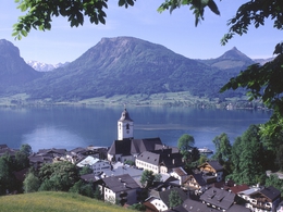
The best way for cyclists to leave Mondsee is to turn left from the market square and then cycle straight on towards the lake. You pass through the magnificent avenue of lime trees with ancient trees to the left and right. At the end, on the way to the lake promenade and the lido, you will find the lake chapel with a large picture of St Wolfgang, where he awakens the spring at Falkenstein. At the main road, however, where the avenue ends, he has to turn right and then continue in the direction of St. Gilgen until he reaches a department store. A path begins at its car park, which then leads into another avenue, this time lined with birch trees. At the end, he crosses the main road again and is thus on the path that leads him via picturesque St. Lorenz to Plomberg. There, following the lakeshore, you can use the cycle path next to the main road, which you stay on until you reach the village of Scharfling. The longer ascent to the Scharfling Pass (604 metres) begins, with a difference in altitude of around 180 metres. Passing Lake Krottensee and Hüttenstein Castle, you reach the turn-off to Fürberg, where you have to decide how to continue. From Fürberg, the Wolfgangsee boat trip takes you comfortably to the district of Ried, where it is only a few hundred metres to St. Wolfgang. Alternatively, you can cycle around Lake Wolfgangsee along the Salzkammergut cycle path and get to St. Wolfgang (approx. 20 kilometres). You can also take the ferry in Abersee (crossing) or the cross-lake ferry to St. Wolfgang. Please note: It is not possible to cross the Falkenstein by bike. In any case, you can reach the pilgrimage church of St. Wolfgang, the destination of so many pilgrims, via all the routes mentioned.
A cultural stop would be the church of St. Georgen an der Mattig with its baroque altars by the Zürn brothers, but unfortunately it is closed and to visit it you have to register at the parish office two days in advance (!). You pass the stately market town of Mauerkirchen and soon catch sight of the tower of St Florian near Helpfau. This church - situated on a hill - is also closed, but together with the fish ponds in front of it, it offers a picturesque photo motif.
The cycle path turns right, crosses the Mattigtal valley and comes to the market town of Uttendorf with a large square and several churches. The route continues on the other side of the valley. The cycle path does not touch the town of Mattighofen, but heads towards Pfaffstätt, where we leave it, turn left into the town and turn right into the road labelled "Munderfing".
Munderfing is a typical Innviertel village, which you drive through until you reach the Landgasthaus Graf, opposite which there is a bridge over the Schwemmbach on the right. Turn left at the next road, but then continue straight on along the Roman road where the road bends to the right at a small chapel. This brings you to the village of Valentinhaft with its church, where a hole in the wall to the right of the entrance marks the spot where St Wolfgang reached through the wall to unlock the church from the inside. Cycle on below the church, turn left in Oberhaft and then right at the railway track. At the "Teichstätt" railway stop, visit the castle that has been transformed into a farm, where St. Wolfgang is known to have stayed. He drew up a document there. Back to the Ledl inn, cross the railway and immediately turn left onto the road that leads to Lengau.
After visiting the "giant grave" at the cemetery next to the church gate, continue in the same direction on the "Barocktour" cycle path to Roidwalchen, which is already in the province of Salzburg and where you turn left into the next larger town, Straßwalchen. Before you get there, you pass a huge car storage centre, where there are separate sectors for each type and make of car.
In Straßwalchen you end up on the market square. Head south towards Salzburg and after a short distance turn into the road leading to Mondsee. A cycle path starts again on the right-hand side, which takes you through the interesting villages of Irrsdorf and Oberhofen, and you are back in Upper Austria. Soon afterwards you can see the Zellersee or Irrsee lake, down into the hollow of which you descend in a lively ride. The route on the western shore is also more recommendable for cyclists as it is far more natural and avoids the busy main road. On the south bank, you stay on the cycle path and reach the old market town of Mondsee on the lake of the same name with its magnificent monastery church. Today, this is a renowned holiday resort.
The best way for cyclists to leave Mondsee is to turn left from the market square and then cycle straight on towards the lake. You pass through the magnificent avenue of lime trees with ancient trees to the left and right. At the end, on the way to the lake promenade and the lido, you will find the lake chapel with a large picture of St Wolfgang, where he awakens the spring at Falkenstein. At the main road, however, where the avenue ends, he has to turn right and then continue in the direction of St. Gilgen until he reaches a department store. A path begins at its car park, which then leads into another avenue, this time lined with birch trees. At the end, he crosses the main road again and is thus on the path that leads him via picturesque St. Lorenz to Plomberg. There, following the lakeshore, you can use the cycle path next to the main road, which you stay on until you reach the village of Scharfling. The longer ascent to the Scharfling Pass (604 metres) begins, with a difference in altitude of around 180 metres. Passing Lake Krottensee and Hüttenstein Castle, you reach the turn-off to Fürberg, where you have to decide how to continue. From Fürberg, the Wolfgangsee boat trip takes you comfortably to the district of Ried, where it is only a few hundred metres to St. Wolfgang. Alternatively, you can cycle around Lake Wolfgangsee along the Salzkammergut cycle path and get to St. Wolfgang (approx. 20 kilometres). You can also take the ferry in Abersee (crossing) or the cross-lake ferry to St. Wolfgang. Please note: It is not possible to cross the Falkenstein by bike. In any case, you can reach the pilgrimage church of St. Wolfgang, the destination of so many pilgrims, via all the routes mentioned.
- All weather
- Suitable for groups
- Suitable for schools
- Spring
- Summer
- Autumn
- Early winter
Please get in touch for more information.
Au 140
5360 St. Wolfgang im Salzkammergut
Phone +43 6138 8003
Fax machine +43 6138 8003 - 81
E-Mail info@wolfgangsee.at
Web www.wolfgangsee.at
http://www.wolfgangsee.at
Interactive elevation profile
Create PDF
Tour-Details
Starting place: 5280 Braunau am Inn
Destination: 5360 St. Wolfgang im Salzkammergut
duration: 6h 18m
length: 95,6 km
Altitude difference (uphill): 884m
Altitude difference (downhill): 683m
Lowest point: 347m
Highest point: 810m
difficulty: easy
condition: easy
panoramic view: Dreamtour
Paths covering:
Asphalt
powered by TOURDATA