

Liebenau - Kammerer-Kreuz


- Suitable for families
- Suitable for kids (all ages)
- culturally interesting
Interactive elevation profile
Create PDF
Tour-Details
Path number: Nr. 39
Starting place: 4252 Liebenau
Destination: 4252 Liebenau
duration: 2h 30m
length: 8,0 km
Altitude difference (uphill): 247m
Altitude difference (downhill): 229m
Lowest point: 908m
Highest point: 1.039m
difficulty: easy
condition: very easy
panoramic view: Some Views
Paths covering:
Hiking trail
powered by TOURDATA
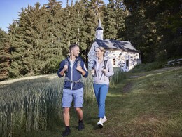
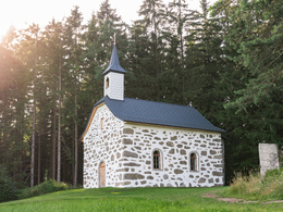
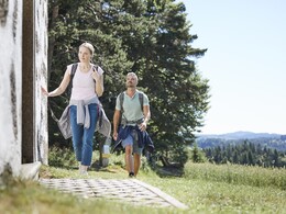
The Steinbloßkapelle Kammerer-Kreuz was once built in place of an image of a saint, which miraculously remained intact after being struck by lightning. It offers a marvellous view of the hills of the Mühlviertler Alm. The Kammerer cross is the closest point on the Johannesweg to Liebenau.
- Suitable for groups
- Suitable for schools
- Suitable for kids (all ages)
- Suitable for teenagers
- Suitable for seniors
- Suitable for single travelers
- Suitable for friends
- Suitable for couples
- Suitable for children
- Spring
- Summer
- Autumn
Please get in touch for more information.
4252 Liebenau
Phone +43 7953 8111
Fax machine +43 7953 8111 - 30
E-Mail marktgemeinde@liebenau.at
Web www.liebenau.at
http://www.liebenau.at
Interactive elevation profile
Create PDF
Tour-Details
Path number: Nr. 39
Starting place: 4252 Liebenau
Destination: 4252 Liebenau
duration: 2h 30m
length: 8,0 km
Altitude difference (uphill): 247m
Altitude difference (downhill): 229m
Lowest point: 908m
Highest point: 1.039m
difficulty: easy
condition: very easy
panoramic view: Some Views
Paths covering:
Hiking trail
powered by TOURDATA