

Silver Trail - Roßleithen Scythe Theme Trail


- culturally interesting
Interactive elevation profile
Create PDF
Tour-Details
Starting place: 4575 Roßleithen
Destination: 4574 Vorderstoder
duration: 2h 0m
length: 4,8 km
Altitude difference (uphill): 394m
Lowest point: 668m
Highest point: 1.065m
difficulty: medium
condition: medium
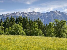
panoramic view: Great panorama
Paths covering:
Asphalt, Gravel
powered by TOURDATA
The "Silver Sensenthemenweg" is almost exclusively in the municipality of Vorderstoder and leads you to the natural idyll Windhagersee. The information boards describe the bond between the farmers and the scythe factory.
From the starting point at the hiking car park, walk a bit in the opposite direction to the other scythe theme trails and, after crossing the Pießling Bridge, you will come to Vorderstoder. You always walk along the Walchegg supply road. After the Brunnstein estate, continue on a forest path. Follow this in the direction of Zellerhütte! Numerous directions show you the hiking trails to the Zeller and Dümlerhütte. At Windhagersee you have reached your destination. You can now continue hiking to the Zellerhütte or take the same route back to Roßleithen. You will be rewarded by the magnificent view!
Silver Scythe Theme Trail: No circular route, walking time 2 hours
Small "silver scythes" show them the way!
Starting point: Hiking car park in the center of Roßleithen
Destination: Windhagersee
further information:
Details - hiking
- themed path
Accessibility / arrival
Hiking car park in the center of Roßleithen
Most economical season
- Spring
- Summer
- Autumn
Please get in touch for more information.

Bahnhofstraße 2
4580 Windischgarsten
Phone +43 7562 5266
Fax machine +43 7562 5266 - 10
E-Mail info@pyhrn-priel.net
Web www.urlaubsregion-pyhrn-priel.at
http://www.urlaubsregion-pyhrn-priel.at
Interactive elevation profile
Create PDF
Tour-Details
Starting place: 4575 Roßleithen
Destination: 4574 Vorderstoder
duration: 2h 0m
length: 4,8 km
Altitude difference (uphill): 394m
Lowest point: 668m
Highest point: 1.065m
difficulty: medium
condition: medium
panoramic view: Great panorama
Paths covering:
Asphalt, Gravel
powered by TOURDATA