

Kösslbachweg Circuit - No. 75


- Flatly
Interactive elevation profile
Create PDF
Tour-Details
Starting place: 4085 Waldkirchen am Wesen
Destination: 4085 Waldkirchen am Wesen
duration: 2h 15m
length: 7,3 km
Altitude difference (uphill): 190m
Altitude difference (downhill): 199m
Lowest point: 444m
Highest point: 600m
difficulty: medium
condition: medium
panoramic view: Dreamtour
Paths covering:
Asphalt, Path / trail, Gravel, Other
powered by TOURDATA
Short description:
Leisurely circular walk
Leisurely circular walk
Technique: **
Quality of experience: ****
Recommended season:
- March
- April
- May
- June
- July
- August
- September
- October
- November
Properties:
- Loop
- Scenic
- Refreshment stops available
- Geological highlights
- Botanical highlights
Starting at 4-4 Blick via Atzersdorf - towards Aichberg - after the farm before Aichberg left to Edt - village - along forest tracks, meadows and fields to Hundorf. In the village centre right into kl. Kösslbachtal back to 4-4 Blick.
Tip:
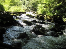
4-4 Blick-panoramic view into the 4 quarters of Upper Austria, wonderful views into Danube Valley, small Kösslbachtal nature reserve, Felsenblick (Rock view),
Equipment:
Hiking backpack (incl. rain cover), sturdy shoes
Starting point: Parking lot - 4-4 view in Atzersdorf
Destination: Parking lot - 4-4 view in Atzersdorf
further information:
- Flatly
- Board possible
Accessibility / arrival
Parking
Parking possibilities
Public Transit
How to arrive in the Danube Upper Austrian region?
The fast way to your destination – by train, bus, car, boat or plane.
Parking
Parking possibilities
Most economical season
- Spring
- Summer
- Autumn
- Early winter
Please get in touch for more information.
Waldkirchen 61
4085 Waldkirchen am Wesen
Phone +43 7718 7255
mobile +43 676 814282810
E-Mail toku.waldkirchen-wesenufer@outlook.com
Web www.donauregion.at/waldkirchen
https://www.donauregion.at/waldkirchen
Interactive elevation profile
Create PDF
Tour-Details
Starting place: 4085 Waldkirchen am Wesen
Destination: 4085 Waldkirchen am Wesen
duration: 2h 15m
length: 7,3 km
Altitude difference (uphill): 190m
Altitude difference (downhill): 199m
Lowest point: 444m
Highest point: 600m
difficulty: medium
condition: medium
panoramic view: Dreamtour
Paths covering:
Asphalt, Path / trail, Gravel, Other
powered by TOURDATA