

Schallenburg castle ruins tour


- Flatly
Interactive elevation profile
Create PDF
Tour-Details
Starting place: 4115 Kleinzell im Mühlkreis
Destination: 4115 Kleinzell im Mühlkreis
duration: 2h 54m
length: 10,3 km
Altitude difference (uphill): 232m
Altitude difference (downhill): 232m
Lowest point: 369m
Highest point: 581m
difficulty: easy
condition: easy
panoramic view: Individual Views
Paths covering:
Asphalt, Street, Hiking trail
powered by TOURDATA
Short description:
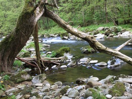
Demanding but extremely beautiful Mühltal hike. From Kleinzell first over a ridge and then steeply sloping into the valley of the Große Mühl, along this (2/3 of the entire length) to the ÖBB-Hst. back via Apfelsbach. Can be extended to a 12.6 km long day tour with the Diesenbachtalweg
Demanding but extremely beautiful Mühltal hike. From Kleinzell first over a ridge and then steeply sloping into the valley of the Große Mühl, along this (2/3 of the entire length) to the ÖBB-Hst. back via Apfelsbach. Can be extended to a 12.6 km long day tour with the Diesenbachtalweg
Technique: *
Quality of experience: **
Recommended season:
- January
- February
- March
- April
- May
- June
- July
- August
- September
- October
- November
- December
Properties:
- Loop
Challenging but very scenic Mühltal hike. From Kleinzell initially across a ridge and then falling off steeply into the valley of Grosse Mühl River, along this (2/3 of the total distance) to the ÖBB-stop back via Apfelsbach. Can be extended into a 12.6 km long day trip when combined with Diesenbachtalweg path.
Starting point: Kleinzell village centre
Destination: Kleinzell village centre
further information:
- Flatly
Accessibility / arrival
Parking
At the town hall or kindergarten
Public Transit
Location and getting there
How to arrive in the Danube Upper Austrian region?
The fast way to your destination – by train, bus, car, boat or plane.
Parking
At the town hall or kindergarten
Most economical season
- Spring
- Summer
- Autumn
- Early winter
- Deep winter
Please get in touch for more information.
Kleinzell 13
4115 Kleinzell im Mühlkreis
Phone +43 7282 5355
E-Mail gemeinde@kleinzell.ooe.gv.at
Web www.donauregion.at/kleinzell
https://www.donauregion.at/kleinzell
Interactive elevation profile
Create PDF
Tour-Details
Starting place: 4115 Kleinzell im Mühlkreis
Destination: 4115 Kleinzell im Mühlkreis
duration: 2h 54m
length: 10,3 km
Altitude difference (uphill): 232m
Altitude difference (downhill): 232m
Lowest point: 369m
Highest point: 581m
difficulty: easy
condition: easy
panoramic view: Individual Views
Paths covering:
Asphalt, Street, Hiking trail
powered by TOURDATA